A Jan Joosten Van Meteren Line: INTRO & DIRECTORY

Deschutes County, Oregon

In this post I will be covering Oregon History and Deschutes County, Oregon communities: Cloverdale, Redmond and Bend, where our Van Matre families settled. The Van Matre’s, early settlers in Central Oregon, were instrumental in the development of the area in the early 20th century.

Oregon History

Map of the Oregon Country, with most heavily disputed area highlighted. The 1846 Oregon Treaty awarded this area to the U.S.
Map of the Oregon Country, with most heavily disputed area highlighted. The 1846 Oregon Treaty awarded this area to the U.S.11

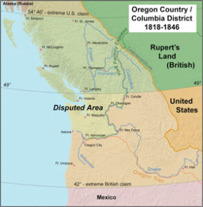
Great Britain and the U.S. both claimed ownership of Oregon. The dispute, friendly at first, escalated into the threat of war before it was resolved amicably in 1846 by splitting the region 50-50.

Following the Anglo American Treaty of 1818, the region was “jointly occupied” by the U.S. and Britain. The Americans referred to the region as Oregon Country, while the British knew it as the Hudson’s Bay Company’s Columbia District, which was administered from Fort Vancouver near present-day Vancouver, Washington.

During the 1820s and early 1830s the American West was explored by private trappers who formed fur trading companies originating from St. Louis. One of these privateer trappers and explorers was Jedediah Smith who led expeditions into the American West.  Smith sent Jackson’s Secretary of War John H. Eaton a letter and map containing information that he had gathered from 1824-1830 of his explorations into the Rockies, the South Pass, and Pacific Northwest. Smith recommended that President Jackson terminate the Treaty of 1818 that gave the British free rein over the Columbia River, and reported that the Indians favored the British over the Americans.

British fur interests tried to block Americans by creating a “fur desert” along the eastern and southern borders by trapping all the animals and leaving nothing for the Americans.

The balance of power shifted in the 1830s as thousands of American settlers arrived, completely dominating the southern half of the disputed region. Joint occupation ended with the signing of the Oregon Treaty in 1846, when Britain and the U.S. split the disputed region equally, along present borders, with the U.S. general receiving lands south of the 49th parallel.1

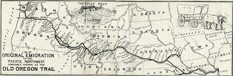
Reports of Oregon Country eventually circulated in the eastern United States. American settlers began to arrive from the east by the Oregon Trail starting in the early 1840s, and came in increasing numbers each subsequent year. Increased tension led to the Oregon boundary dispute. Both sides realized that settlers would ultimately decide who controlled the region. The Hudson’s Bay Company, which had previously discouraged settlement as it conflicted with the lucrative fur trade, belatedly reversed their position. In 1841, on orders from Sir George Simpson, James Sinclair guided more than 100 settlers from the Red River Colony to settle on HBC farms near Fort Vancouver. The Sinclair expedition crossed the Rockies into the Columbia Valley, near present-day Radium Hot Springs, British Columbia, then traveled south- west down the Kootenal River and Columbia River following the southern portion of the well established York Factory Express trade route.

The Canadian effort proved to be too little, too late. In what was dubbed “The Great Migration of 1843” or the “Wagon Train of 1843”, an estimated 700 to 1,000 American emigrants came to Oregon, decisively tipping the balance. Britain gave up claims to its portion of the Columbia District south of the 49 parallel to the United States by the Oregon Treaty in 1846.

The Oregon Trail started in St. Louis, Missouri.
The Oregon Trail started in St. Louis, Missouri.12
In 1848, the U.S. portion of the Oregon Country was formally organized as the Oregon Territory. In 1849, Vancouver Island became a British Crown colony –the Colony of Vancouver Island, with the mainland being organized into the Colony of British Columbia in 1858. Shortly after the establishment of Oregon Territory there was an effort to split off the region north of the Columbia River, which resulted in the creation of Washington Territory in 1853.
Advertisement:

Gaining Statehood

Oregon City served as the seat of government from 1848 to 1851, followed by Salem from 1851 to 1855. Corvallis served briefly as the captital in 1855, followed by a permanent return to Salem later that year. In 1853, the portion of the territory north of the lower Columbia River and north of the 46th parallel east of the river was organized into the Washington Territory. The Oregon Constitutional Convention was held in 1857 to draft a constitution in preparation for becoming a state.

On February 14, 1859, the territory entered the Union as the U.S. state of Oregon within its current boundaries. The remaining eastern portion of the territory (the portions in present-day southern Idaho and western Wyoming) was added to the Washington Territory.

The following is a visual view of the transition from Oregon Territory in 18482, Washington Territory in 18533 and Oregon State and extension of Washington Territory in 18594:

Oregon Territory to Oregon State 1848-1859.

Oregon Counties

Oregon currentlyl has 36 counties. The county our family migrated to between 1908-1914 wass Crook county. Deschutes County was formed out of Crook county in 1919.

Oregon Counties Map edited
Oregon Counties Map edited13

County Changes for Central Oregon

1843 – Champoeg County was formed (original)

1843 – Clackamas County was formed (original)

1847 – Linn County was formed out of Champoeg County

1849 – Marion County (rename of Champoeg County)

1854 – Wasco County was formed out of Marion, Clackamas and Linn Counties.

1882 – Crook County was formed out of Wasco Coumty.

1882 – Crook County was formed out of Wasco County.

1889 – Sherman County was formed out of Wasco County.

1914 – Jefferson County was formed out of Crook County.

1916 – Deschutes County was formed out of Crook County.


Advertisement:

Deschutes County, Oregon History

The following are excerpts from a “paper” I found online that provides the early history of the county and Fred Nathan Van Matre’s involvement as contractor for the County Library. Unfortunately, there is no author name, source or date, but can be found on the Deschutes County Website:5

Located in the heart of the state, Deschutes County is the outdoor recreation capital of Oregon. With snow-capped peaks dominating the skyline to the west and the wide-open high desert extending to the east.

Europeans had begun exploring present day Deschutes County as early as 1813. That year a fur trading party from the American Fur Trading Company came through the area looking for beaver. The party, led by Reed and Seaton, carved their initials and date on a large stone on the banks of the Deschutes River, just south of present day site of Bend. (Today the rock can be found at the Deschutes County Historical Society.)

In 1859 Oregon gained statehood, however Central Oregon remained largely unsettled. Three years later the first real settler arrived in Central Oregon. Cattle ranchers, Filix Scott, Jr., Marion Scott, John Craig and Robert Millican brought 900 head of cattle into the region and spent the winter here. They are reputed to be the first white people to do so. Most of the early settlers of today’s Deschutes County were sheep, cattle, and wheat and potato farmers. In fact, potato farming was so popular that at one point the Deschutes County Fair was actually first known as the Annual Potato Show.

By 1900, the Columbia Southern Railroad had only reached Shaniko, then the largest town in the region. Regardless, the future of central Oregon looked bright. Midwestern businessman Alexander M. Drake had arrived on the backs of the Deschutes River and by 1900 had platted the City of Bend. Within five years the city incorporated with approximately 500 people.

Other businessmen followed Drake’s lead. In 1901, the City of Sisters was officially platted, and in 1904 Tumalo was platted as Laidlaw. Further investment came after the arrival of the railroad in 1911. Other future town sites were platted such as Terrebonne (originally known as Hillman), Redmond and LaPine.

The creation of Deschutes county began in 1914 when a failed attempt was made to move the Crook County seat from Prineville to Bend. At the time, Bend was billed as the “spot of the railroad, in the actual center of business, population, and taxable property in Crook County.” Despite the best efforts of Bend businessmen, the vote failed by a bare margin of 1 1⁄2 percent.

Backers of the proposal believed that if removal of the county seat wasn’t possible, then division into a separate county would be the next best option. As a result, the November 1916 election showed an overwhelming vote for the formation of a new county, present-day Deschutes county.

Shortly after the election however, Crook County sent her latest child, Deschutes County ( Jefferson county had been the first to break off of Crook County in the 1914 election) a Christmas present marked “do not open until Christmas.” The package was found to be a set of quo-warranty proceedings against the members of Deschutes County’s new court, questioning their right to conduct a separate county government. After a recount of the ballots and adjustments in the votes, on December 13, 1916 Governor George Withycombe proclaimed Deschutes County’s official existence.

By 1915 two large companies, Shevlin-Hixon and Brooks-Scanlon, announced plans to build lumber mills just south of downtown Bend. By the mid 1920s, the lumber capacity combined for both mills was one of the largest white pine lumber mills in the world. By 1924, Shevlin-Hixon alone was cutting 200 million board feet a year.

The arrival of the lumber mills brought a large building boom and rapid expansion for the county’s population. In 1916, when the county was formed, the population was just 5,000 people. By 1920 it grew to 9,622, almost doubling in size in just four short years.

The first official offices for the Deschutes County were in the O’Kane Building, built the same year the county was founded. Later, the offices moved across the street to the 1st National Bank, now the site of US Bank in downtown Bend. By 1935 the county had outgrown its offices and moved into its third home, the old central school. The County was actually renting the building and had negotiated a purchase price of $35,000 from the school district when on February 10, 1937 a mysterious fire destroyed the building.

Coincidentally, County Clerk Mable Livesay had reported problems in balancing the books and had requested an audit from the state, which had begun the day before the fire broke out. After working all day, the auditors requested to see the books from the time of the county’s formation. However, due to the fire, most of the requested records were lost including marriage indexes, mortgages and deed index, warrant records, school superintendent records, and the complete law library. Tax records dating back to the formation of the county were found however, secure in the safe.

Investigators discovered that the fire was started in the southwest corner of the building, on a night when the winds were blowing from a direction that could rapidly spread the flames.Telephone wires to the building had been cut forcing the railroad switchman who first saw the blaze, to run 6 blocks to the fire hall. Naturally state officials suspected arson, but to this day no one has been charged with setting the fire.

The need for a permanent home and the first real courthouse for the county were immediately apparent after the fire. Plans began within 12 hours of the blaze for a new home. With the help of a $67,000 PWA grant, $17,000 worth of clearing and excavation cost by the WPA, and a $48,000 tax levy money, construction of the new county courthouse began in February of 1940. Designed by Truman Phillips of Tourtellote & Phillips architects, the new county courthouse was modeled after the Linn County Courthouse in Albany.

During this same period, the first official home of the Deschutes County Library was completed by local contractor Fred Van Metre [Van Matre] on Wall Street in Bend. In 1941 Roberts Airfield was completed allowing flight travel in and out of Central Oregon for the first time. The field was further developed as a training base during WWII for P-38 and B-17 bombers and then given to the City of Redmond after the war.

By 1950 Shevlin-Hixon had sawed its last log, and Deschutes County’s population had reached almost 22,000. The 1960s saw further growth in the region with plans being made to convert Camp Abbot into Sunriver. Bachelor Butte Ski Lodge opened for business and Central Oregon Community college broke ground for its campus on Awbrey Butte after outgrowing its initial site on Wall street.

By 1980 Deschutes County’s population had reached the 50,000 mark and Brooks-Scanlon Lumber Company sold their timber interests to Diamond International symbolizing the end of the logging era. With that change came the shift in the main industry from logging to tourism.

During the past 10 years, Deschutes County has experienced the most rapid growth of any county in the state largely due to its invigorating climate and year-round recreation activities. Central Oregon offers downhill and cross-country skiing, snowboarding, fishing, hunting, hiking, rock climbing, white water rafting, and golfing. Deschutes county is proud to be the hosting are of diverse annual events including the Cascade festival of Music, the Bend Art Hop, Cascade Children’s Festival, P ole Pedal Paddle, Sisters Rodeo, Sunriver Sunfest, the Cascade Cycling classic and the Deschutes county Fair (now housed in one of the newest and largest fairground and expo center facilities in the west).

Advertisement:

Deschutes County, Historical Highlights

The following highlights were obtained from a ‘paper’ posted on the deschutes.org website. No author or date was available.6.

1813 First white men to enter Central Oregon: Reed and Seton from the American pacific Fur Company.

1843 Fremont Exploration: lead by John C. Fremont and his party which included Kit Carson, klThomas “Bad hand” Fitzpatrick, and Billy Chinnook.

1848 Oregon Territory created.

1851 Clark Party camps on the bank of the Deschutes River near the future townsite of Bend.

1859 Oregon gains Statehood.

1862 Felix Scott Jr, Marion Scott, John Craig and Robert Millican bring 900 head of Cattle into central Oregon and spend the winter here. Reputed to be the first white men to do so.

1874 William P. Vandvert settles on the Deschutes River south of present site of Sunriver.

1877 Farewell Bend Ranch established by John Y.k Todd.

1878 Tetherow Crossing built (oldest home standing in Deschutes County).

1882 Crook County formed from Wasco County.

1886 Post Office established at Farewell Bend Ranch by John Sisemore.

1894 Passage of Carey Act which allow free land to those who irrigate it, opens the high desert to development.

1900 Columbia Southern Railroad reaches the City of Shaniko. [Shaniko is located just off Hwy 97 north of Antelope and Northeast of Warm Springs.]
Alexander M. Drake arrives in the future town of Bend.

1901 City of Sisters platted.
Construction begins on Pilot Butte Canal.

1902 Name of post office changed temporarily from “Bend” to “deschutes”.
Millard Triplett constructs Bend’s first frame building.

1903 Bend population reaches approximately 250 people.

1904 Tumalo platted as Laidlaw.
Water turned on in the Pilot Butte Canal.
First phone lines laid between Bend and Prineville.

1905 City of Redmond platted.
City of Bend officially incorporated with 500 people (104 votes in favor – 3 in opposition).

1909  Terrebonne platted as Hillman.

1908 Deschutes National Forest established.

1909 Race up the deschutes River canyon by the Union Pacific RR and the great Northern RR begins.
Terrbonne platted as Hillman.

1910 City of Redmond incorporated.
LaPine platted as town site.
First electric light turned on in Bend and Redmond.
First attempt made to create Deschutes County from part of Crook County.

1911 Great Northern RR (Oregon Trunk Line) reaches Bend and Redmond.
First tuff stone building erected in Bend ( J.I. West Building).

1912 First stucco structure built in Bend (Dream Theatre on Bond street).
Mrs. S. M. Whitted of Bend becomes the first woman in Oregon to vote in a local election.
Mrs. Hattie Corkett of bend becomes the first woman in Oregon to sit on a jury.
Mrs. Della W. Nichols of Laidlaw (Tumalo) becomes first woman candidate in deschutes co. (running for school superintendent).
Vernon A. Forbes become first person from Bend to be elected to a statewide office.

1914 Jefferson County formed from part of Crook County.

1915 Shevlin-Hixon Company builds lumber mill in Bend.
Redmond Potato show begins (forerunner of County Fair).
Gold discovered outside of Redmond on the Deschutes River.

1916 Brooks-Scanlon Lumber Company builds lumber mill in Bend.
Deschutes County existence officially proclaimed by Governor Withycombe on Dec. 13th.

1917  U.S. enters World War I on April 2nd.
17th Amendment passed by Congress allowing prohibition.

1918 First Deschutes County WWI deaths: Percy Steven (Bend) and Elmer Houston (Redmond).
Deschutes County Fair Association established.[W.W. Van Matre was President of the Fair Board for many years. The rodeo grounds were called the Van Matre Rodeo grounds, dates unknown]
WWI ends on November 11th.

1920 Drake Park created by city bond levy.
Brooks-Scanlon Lumber Company reaches a payroll of over 1 million dollars.
Shevlin Park donated to City of Bend by Shevlin-Hixon Lumber Company.19th
Amendment to the constitution passed giving women the right to vote (August 26th).
Mail Carrier service starts in Bend.
Assessing of property begins in Bend.
Deschutes County Library Board organized.
Women’s Civic Improvement League builds “day Nursery”.
Bend Civic Council organized to promote community welfare and growth.

1921 First streets to be paved in Bend (Wall, Bond, Congress and Delaware Avenue).

1922 Half of the town of Sisters burns to the ground in a fire. Next year, other half is destroyed,
John Sisemore cabin from the Farewell Bend Ranch demolished.
First water fountain installed in Bend on Wall street.
Deschutes County Library Board organized.
Bend Civic League organized to promote community welfare and growth.

1923 Over a million boar dfeet of lumber cut by Brooks-Scanlon Lumber Company.

1924 Harmon Park in Bend established by graant from harmon Foundation of New York city.

1925 McKenzie Highway completed.

1926 Rear of the Congress Street Apartments in Bend dynamited by moonshiners.

1927 Charles Lindberg flies the first non-stop flight across the Atlantic Ocean.

1929 Stock Market crashes leading to the great depression.

1931 Natural Gas Service extended into Bend.

1932 Amelia Earhart becomes first woman to fly solo across the Atlantic (2nd wife of former Bend resident George P. Putnam).

1933 First Water Pageant held on Mirror Pond in Bend.
Prohibition repealed by Congress.

1934 6th Street in Redmond paved.

1937 Deschutes County Courthouse destroyed by mysterious fire (old 2nd Central School).
Amelia Earhart (wife of former Bend resident G.P. Putnam) disappears over the Pacific on her round-the-world flight.

1938 First commercial radio broadcast in Central Oregon (KBND).
First permanent home of the Deschutes County Library completed.
Camp Redmond CCC camp established outside of Redmond (largest CCC Camp on west coast). 

1939 Deschutes County Courthouse completed, Truman Phillips architect.
WWII begins with the German invasion of Poland.

1940 Construction of a modern airport at Roberts Field begins in Redmond. 

1941 U.S. enters WWII after a surprise attack on Pearl harbor.

1942 U.S. leases Roberts Field for a WWII B-17 bomber and P-38 training base.

1945 WWII ends with the Japanese surrender aboard the USS Missouri
Commercial air service begins in Central Oregon.

1946 City of Sisters incorporated.

1948 First jet plane lands in Central Oregon at Roberts Field in Redmond.

1950 Shevlin-Hixon lumber Company saws its last log on December 23rd.

1951 Streets in downtown Redmond changed to a one-way grid system.

1959 Downtown Redmond transformed into “board town” for State Centennial Celebration. 

1963 COCC breaks ground for campus on Awbrey Butte.
President Kennedy shot in Dallas, Texas.

1964 Astronauts arrive in Central Oregon to train at Lava Lands for moon landing.

1965 Kah-Nee-Tah resort opens for business.
Sunriver master plan developed

1967 Bond and Wall Streets in bend become a one-way grid.

1972 Pilot Butte Inn becomes first building in Deschutes County to be listed on the National Register of Historic Places.

1980 Brooks-Scanlon Lumber Company sold to Diamond International.

1990 Awbrey Hall fire destroys numerous homes west of Bend.

1991 Oregon Trunk Rail Road trestle across the Deschutes River demolished.

1992 Daw/Crown Pacific Lumber Mill (formerly Brooks-Scanlon Mill) closes.

2001 City of Bend received approval for first National Register Historic District.

Advertisement:

Cloverdale, Deschutes County, Oregon

Cloverdale Fire Station, Deschutes County, Oregon
Cloverdale Fire Station, Deschutes County, Oregon14

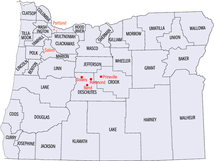
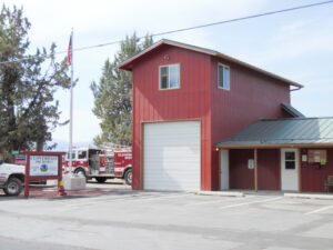
Cloverdale is an unincorporated community in Deschutes County [originally Crook County], Oregon. It is located about five miles east of Sisters [between Sisters and Redmond], on Oregon Route 126. In the late 19th century, Cloverdale became important stop on the A.J. Warrin Road, an alternative route to the Santiam Wagon Road on the way to Prineville. The community provided services for travelers and local homesteaders, with a store, blacksmith shop, and facilities for camping and boarding horses. By the 1920’s or 1930s, the route fell into disuse and the buildings either fell down, were torn down, or moved.

Cloverdale was named by R.A. Ford, a local farmer who was also a teacher and a county school superintendent. He surveyed the nearby Cloverdale Ditch, which is parallel to Whychus creek. The ditch is used for irrigation. Crops grown in the area include clover, alfalfa, potatoes, grasses and vegetables. The one-room Old Cloverdale School was built on George Cyrus Road (a.k.a. Cloverdale Market road). Also, known as the Cyrus School, it is listed as a historic resource by Deschutes County. A new school was built in 1919. The 1919 school shares a site with the Cloverdale rural Fire Protection District station and as of 2011 was in use as a preschool.

Section in Deschutes County - 1935 - area where the van Matre Families settled, including Cloverdale, Redmond and Bend.
Sections in Deschutes County Plat Map- 1935 - area where the Van Matre Families settled, including Cloverdale, Redmond and Bend.
Advertisement:

Redmond, Deschutes County, Oregon

The final place in our journey west, Redmond is a city in Deschutes County, Oregon, incorporated on July 6,1910. The population of Redmond at that time was 216. The city is on the eastern side of Oregon’s Cascade Range, in the High Desert in Central Oregon.

From Redmond, there is access to recreational opportunities, including mountain biking, fishing, hiking, camping, rock climbing, white- water rafting, skiing, and golf. Redmond is a full-service municipality and one of the fastest-growing industrial and residential communities in Oregon. Redmond is about 17 miles Northeast of Bend, Oregon.7

Downtown Redmond, Oregon ca 1925

History of Redmond, Oregon

Irrigation water was two years in the future and the railroad seven years away when schoolteachers Frank and Josephine Redmond pitched their tent on right-of way for the projected canal and railroad northeast of what would become their namesake downtown in 1904. Each week until irrigation water reached their farm, the Redmond’s hitched the horses to a wagon and made the 10-mile round trip to the Deschutes River at Cline Falls to fill a leaky wooden tank with water. Once home they filled every container that would hold water – pitchers, jars, bowls and basins – with enough water for people and animals until the next trip.

Once water flowed through the canals, farmers, lured by the prospect of free homestead land, speculators and business people looking to set up shop, flowed into the area, all aided by the knowledge that the railroad was coming.

The burgeoning community was incorporated as the City of Redmond on July 6, 1910, with a population of 216.

One of the oldest continuously operated businesses in the city of Redmond is The Redmond Spokesman. The following is a bit of interesting history about The Spokesman:8

It was first published on 14 July 1910. The paper’s first publisher was Henry H. Palmer. He had previously published a newspaper in the neighboring town of Tumalo. Palmer operated the newspaper with his wife Clara, who was also an experienced journalist. In September 1911, the Palmers announced that The Spokesman had acquired a new press and paper cutter to improve newspaper printing and production. A Typesetting machine was added a short time later. In January 1912, the new 1200-pound linotype machine was installed to further improve the operation.

However, on 26 February 1912 a fire started in a neighboring hardware store. The fire spread to adjacent buildings, burning down a grocery store, a bakery, a furniture store, and The Spokesman office. Despite the fact that the loss exceeded their insurance coverage by $4,000, the Palmers were able to keep the newspaper going by using the presses at Redmond’s other newspaper, The Oregon Hub and at the The Bulletin in nearby Bend to print The Spokesman while new equipment was ordered.

The Redmond Spokesman, ca 1912.

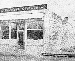
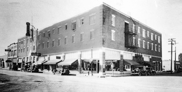
After several months in temporary quarters, the paper moved into a new stone building on the old office site. When new equipment, including another modern linotype machine, was installed the Palmers began printing. The Spokesman in their own production facility again. The sign on top of the new office building announcing the home of “The Redmond Spokesman” was 3 feet high and 24 feet long.

The Spokesman was Redmond’s second paper. Its competition was The Oregon Hub, which was founded in 1909. A third community paper, the Redmond Enterprise, began publication in 1913. In 1914, the Palmers bought out the other two newspapers, leaving The Spokesman as Redmond’s only newspaper.

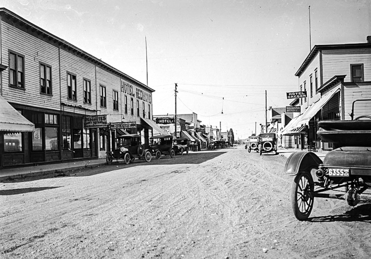
In the fall of 1911, the construction crews for the Oregon Truck Line railroad arrived in Redmond and drove a “golden” spike at what is now Evergreen Avenue, connecting the little town to the world for both export of its agricultural products and transportation of passengers in and out.

Women voted for the first time in Redmond on November 1912 when they participated in a nominating caucus for mayor and city council candidates.

As the result of easier access and new opportunities brought by the canal system, new residents flocked to the area in the 1910s and 20s, establishing farms, ranches and businesses. By 1930 1,000 people called the city home.

Redmond Union High School (RUHS) built in 1922.

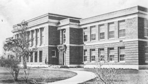
The 1920s also saw construction of Redmond’s largest historic buildings and the beginnings of its airport. The two-story brick Redmond Union High School was built in 1921. At the 1922 dedication, State Superintendent of Public Instruction J.A. Churchill called the $100,000 school as “a very great achievement” in the history of rural education. After a new High School was built in 1971, the school was converted into a junior high, and eventually becoming Evergreen Elementary. The property sat vacant for a time while consideration for rehabilitation stalled. In 1914, a plan was approved to upgrade the building and it is now the current location of the Redmond City Hall.

Crooked River High Bridge , Jefferson County, Oregon
Crooked River High Bridge,
Jefferson County, Oregon15

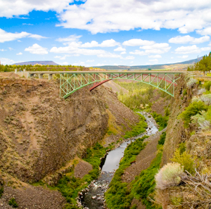
Redmond gained easier access by motor vehicle with the 1926 completion of the High Bridge over Crooked River Gorge that connected segments of The Dalles-California Highway (Highway 97) without the trouble of zigzagging up and down the canyon walls at Trail Crossing about a mile east of the current highway bridges. When the new Highway 97 bridge, the Rex T. Barber Veterans Memorial Bridge, was completed in 2000, the original highway bridge was designated for pedestrians.

In 1928, just one year after a fire destroyed the block with the original wood frame Redmond Hotel, the three-story brick New Redmond Hotel opened to guests. [The building was constructed by a local contracting firm led by Ole K. Olson and his partner S. Elmer Erickson. Another general contractor, Fred N. Van Matre, also helped with the construction.9

The New Redmond Hotel

Roberts Field-Redmond Municipal Airport, Central Oregon’s regional airport, traces its origins to 1928 when members of Redmond’s Ray Johnson American Legion Post staked out land a mile southeast of downtown for an airfield. Over the following year, volunteers the Legion and the Redmond Commercial Club (forerunner of the Chamber of Commerce) scraped the first dirt runways from the desert landscape a mile southeast of downtown.

Redmond’s population grew slowly, but steadily to 7,165 in 1990. Ensuing years saw the number of city residents explode. Between 2000 and 2006 the city’s population grew by more than 74 percent, making it among Oregon’s fastest growing communities. In July 2013, the population was certified at 26,590, showing that 52% of the residents of Redmond moved there in the past 10 years.

The wood products industry that began in the 1930’s continued to thrive until the 1980’s. Potatoes, the long-time king of Redmond-area agricultural commodities, disappeared in the ‘80’s. today the city’s economy is driven by assorted small manufacturing, retail, government and healthcare services and tourism.

Redmond OR ca 1960

Redmond, Oregon Population10

1910 – 216
1920 – 585
1930 – 994
1940 – 1876
1950 – 2956
1960 – 3340
1970 – 3721
1980 – 7257
1990 – 7257
2000 – 15288
2010 – 26215
2014 – 27941
2022 – 37,556

Citations and Attributes:

Table of Contents

  1. Wikipedia (http://en.wikipedia.org), "History of Oregon", rev 16:43, 25 September 2018.(accessed 1 Oct 2018)
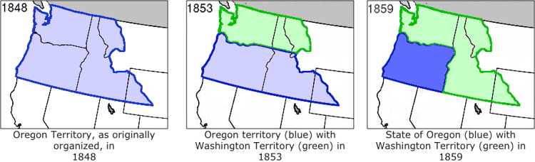
  2. Oregon Territory, as originally organized, in 1848. By Matthew Trump - w:en:Image:Wpdms oregon territory 1848.png, CC BY-SA 3.0, https://commons.wikimedia.org/w/index.php?cu- rid=996610
  3. Oregon Territory (blue) with Washington Territory (green) in 1853. By Matthew Trump - w:en:Image:Wpdms oregon washington territories 1853.png, CC BY-SA 3.0, https://commons. wikimedia.org/w/index.php?curid=996609
  4. State of Oregon (blue) with Washington Territory (green) in 1859. By Matthew Trump - w:en:Image:Wpdms oregon Washington territory 1859.png, CC BY-SA 3.0, https://commons. wikimedia.org/w/index.php?curid=996611
  5. Deschutes County History, accessed at the Deschutes County website at https://www.deschutes.org/sites/default/files/fileattachments/community_development/page/795/history_of_deschutes_county.pdf (Accessed 5 aug 2023).
  6. Deschutes County Highlights, obtained from 'paper' posted on the Deschutes County Website at https://www.deschutes.org/sites/default/files/fileattachments/community_development/page/795/deschutes_county_historical_highlights.pdf (Accessed 5 Aug 2023]
  7. Redmond, Oregon, Wikipedia (https://.en.wikipedia.org), "Redmond, Oregon", rev 19:27, 14 June 2017.
  8. The Redmond Spokesman",Wikipedia (http://en.wikipedia.org), "The Redmond Spokesman", rev 20:04, 26 September 2016.(accessed 24 Aug 2017).
  9. The New Redmond Hotel -Wikipedia (https://.en.wikipedia.org), "New Redmond Hotel", rev 22:25, 05 May 2017.
  10. "Population.us." Redmond, Oregon population. Accessed 04 August 2017. http://population.us/or/redmond/.
  11. Oregon Country / Columbia District 1818-1846.By No machine-readable author provided. Kmusser assumed (based on copyright claims). – No machine-readable source provided. Own work assumed (based on copyright claims)., CC BY-SA 2.5, https://commons.wikimedia.org/w/ index.php?curid=684354
  12. The Oregon Trail started in St. Louis, Missouri. Public Domain, https://commons.wikimedia. org/w/index.php?curid=146973
  13. Oregon Counties. Par United States Census Bureau — http://www.fedstats.gov/qf/maps/ oregon_map.html, Domaine public, https://commons.wikimedia.org/w/index.php?cu- rid=1253331
  14. Cloverdale fire station. By Orygun – Own work, CC BY-SA 4.0, https://commons.wikimedia. org/w/index.php?curid=36327364
  15. Crooked River High Bridge in Jefferson County, Oregon. Taken from the Peter Skene Ogden State park. By Cacophony – Own work, CC BY-SA 3.0, https://commons.wikimedia.org/w/in- dex.php?curid=2155806

Disclosure:
The family Information was retrieved from a variety of family trees, webgens and family stories. I will note citations as appropriate and hope the information assists you in your research, but please do not use this as proven evidence. Feedback is welcome!

Pat Burns. Copyright © 2024. All Rights Reserved.
Facebook
Twitter
LinkedIn

Leave a Reply

Your email address will not be published. Required fields are marked *