A Jan Joosten Van Meteren Line: INTRO & DIRECTORY

History of Maryland

In 1498 the first European explorers sailed along the Eastern Shore, off present-day Worcester County. In 1524 Giovanni da Verrazzano, sailing under the French flag, passed the mouth of Chesapeak Bay. In 1608, John Smith entered the bay and explored it extensively.

Pennsylvania and Maryland Colony Boundaries

Province of Maryland, 1632-1776
Province of Maryland 1632-1776.2

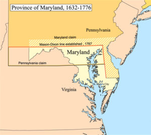
George Calvert, 1st Baron Baltimore, applied to King Charles I for royal charter for what was to become the Province of Maryland. After Calvert died in April 1632, the charter for “Maryland Colony” (in Latin Terra Mariae) was granted to his son, Cecilius Calvert, 2nd Baron Baltimore, on 20 June 1632 and served as the Proprietary Governor from 1634 to 1647.

Based on an incorrect map, the original royal charter granted Maryland the Potomac River and territory northward to the fortieth parallel. This was found to be a problem, as the northern boundary would have put Philadelphia, the major city in Pennsylvania, within Maryland. The Calvert family, which controlled Maryland, and the Penn family, which controlled Pennsylvania, decided in 1750 to engage two surveyors, Charles Mason and Jeremiah Dixon, to establish a boundary. They surveyed what became known as the Mason-Dixon Line, which became the boundary between the two colonies.

However, when Mason and Dixon surveyed the Maryland-Pennsylvania boundary, they could not continue the line the required five degrees of longitude west of the Delaware River. The local Indians refused to let white men with the survey instrument that they thought would “steal the Indian’s land” pass westward beyond a branch of the Catawba Path. It was not until 1784, after we had won our Independence, that Virginia and Pennsylvania finally agreed to find and set the present western boundary at five degrees of longitude west of the Delaware River where it bisects Pennsylvania’s southern boundary.

Table of Contents

Advertisement:

Barons Baltimore and the Catholic Colony

Maryland is one of the smallest U.S. States in terms of area, as well as one of the most densely populated. Many of the counties in Maryland were named for relatives of the Barons Baltimore, who were the proprietors of the Maryland colony from its founding in 1634 through 1771. The Barons Baltimore were Catholic, and George Calvert, 1st Baron Baltimore, originally intended that the colony be a haven for English Catholics, though for most of its history Maryland has had a majority of Protestants.

As did other colonies, Maryland used the headright system (a legal grant of land to settlers) to encourage people to bring in new settlers. Led by Leonard Calvert, Cecil Calvert’s younger brother, the first settlers departed from Cowes, on the Isle of Wight, on November 22, 1633 aboard two small ships, the Ark and the Dove. They landed on March 25, 1634, at St. Clement’s Island in southern Maryland. This was the site of the first Catholic mass in the Colonies.

After purchasing land from the Yaocomico Indians and establishing the town of St. Mary’s, Leonard, per his brother’s instructions, attempted to govern the country under feudalistic precepts. Meeting resistance, in February 1635, he summoned a colonial assembly. In 1638, the Assembly forced him to govern according to the laws of England. The right to initiate legislation passed to the assembly.

In 1638, Calvert seized a trading post in Kent Island established by the Virginian William Claiborne. In 1644, Claiborne led an uprising of Maryland Protestants. Calvert was forced to flee to Virginia, but he returned at the head of an armed force in 1646 and reasserted proprietorial rule.

Maryland soon became one of the few predominantly Catholic regions among the English colonies in North America and was also one of the key destinations where the government sent tens of thousands of English convicts punished by sentences of transportation. Such punishment persisted until the Revolutionary War.

Our Van Metre Family settled for a time just south of Frederick, Maryland. 

Maryland is one of the original Thirteen Colonies. It was the seventh state to ratify the United States Constitution and played a pivotal role in the founding of Washington, D.C., which was established on land donated by the state.

Maryland Map, showing location of Frederick, Annapolis, St. Clements Island and St. Mary's City.

Prince Georges County, Maryland 1725-1735

In 1725, when John Van Metre acquired his land grant in Maryland, it was in Prince George’s County. At that time Prine Georges County included what is now Montgomery and Frederick County. The map below shows the current three counties in red, blue green and blue.  Metres Run, was in what is now Frederick County, just south of the town of Frederick.

Map of the State of Maryland. The Counties of Frederick (red), Prince George's (blue) and Montgomery (green). In 1725, these three counties were all in Prince George's County. Metre's Run was in what is now Frederick County just south of the town of Frederick.

Map of the State of Marlylland. The Counties of Frederick (red), Montgomery (green) and Prince George’s (blue). In 1725,
these three counties were all in Prince George’s County. Metre’s Run was in what is now Frederick County, just south
of the town of Frederick.

The land granted to John Van Metre on November. 3, 1726 by Lord Baltimore, a tract of two hundred acres and called Metre’s Run, was believed to be located in the area that the Monocacy Battle was fought during the Civil War. This was in Prince Georges County (now just south of Frederick, Frederick County, Maryland.

“He also acquired other lands in Maryland, some of which lay upon the Antietam Creek in what is now Washington County (the county to the left of Frederick County). 

The Dutch element, perhaps, were the first to establish themselves in these localities; coming down from New York by way of Pennsylvania, they were found in western Maryland as early as 1725. One of the most traveled paths from the German settlements of Lancaster and York counties, Pennsylvania, which led to Maryland was the Monocacy-Conocochegue road, which was evolved from an Indian trail. The Conococheague road led southward from a point five miles west of Codorus creek in York County, Pennsylvania, where the Monocacy road makes a bend toward the southwest, and led to Fort Conococheque in the Cumberland Valley, Pennsylvania, then to Fort Frederick on the Potomac. 

John Van Metre probably traveled from Somerset County, New Jersey, although his brother Isaac would have traveled from Salem County, New Jersey. It is probably due to John Van Metre that his friends and relatives began to colonize along the Monocacy River, for here were found the Eltings, Vernoys, Croms, Van Metres and other families from the Hudson River communities.

Frederick, Maryland to Potomac River and showing location of the Monocacy Battle (Civil War). This is about where John Van Metre's "Metre's Run" was believed to be located.

Frederick, Maryland to Potomac River and showing location of the Monocacy Battle (Civil War).
This is about where John Van Metre’s “Metre’s run” was believed to be located.

Maryland Counties Map

The following is the current Maryland Counties Map.  Frederick County Place name changes:

  • 1654 Calvert and Charles Counties were formed
  • 1696 Prince Georges County was formed from Calvert and Charles Counties
  • 1748 Frederick County was formed from Prince Georges County.
  • 1776 Montgomery County was formed from Frederick County.
  • 1788 A section of Montgomery County was set off to form the District of Columbia.
Current Counties Map of Maryland.

Current Counties Map of Maryland.1

Advertisement:

Attributes:

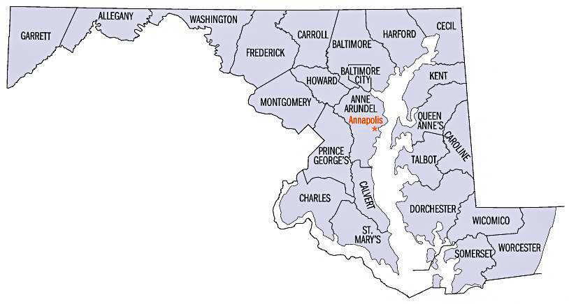
  1. Map of Maryland Counties. By Unknown - http://www.fedstats.gov/qf/maps/stout24.gif, Public Domain, https://commons.wikimedia.org/w/index.php?curid=5257547 (Accessed 30 Mar 2023)
  2. Province of Maryland 1632-1776. By Karl Musser – Karl Musser, CC BY-SA 3.0, https://commons.wikimedia.org/w/index.php?curid=1331400. This file is licensed under the Creative Commons Attribution-Share Alike 3.0 Unported license.

Disclosure:
The family Information was retrieved from a variety of family trees, webgens and family stories. I will note citations as appropriate and hope the information assists you in your research, but please do not use this as proven evidence. Feedback is welcome!

Pat Burns. Copyright © 2024. All Rights Reserved.
Facebook
Twitter
LinkedIn

Leave a Reply

Your email address will not be published. Required fields are marked *