A Jan Joosten Van Meteren Line: INTRO & DIRECTORY

New Netherlands Colony

Jan Joost Van Meteren and his family arrived in the “New Amsterdam, New Netherlands” in 1662. They traveled up the Hudson River to Wiltwick (now Kingston, New York).  This is just a short bit of history of New Netherlands and New Amsterdam as they knew it when they arrived. 

New Netherlands extended from Albany, New York, in the north to Delaware in the south and encompassed parts of what are now the states of New York, New Jersey, Pennsylvania, Maryland, Connecticut and Delaware. The Dutch claim to this territory was a result of their sponsorship of Henry Hudson’s voyages of exploration.  

Table of Contents

Henry Hudson 1609-1611

Hired by English merchants, explorer Henry Hudson twice entered the Arctic Ocean to find a Northeast Passage to Asia, only to be stymied each time by sheets of sea ice. Though unable to gain additional backing in his home country, the state-sponsored Dutch East India Company soon jumped in to green-light a third voyage. In April 1609, Hudson set off on his ship, the Halve Maen (Half Moon), but quickly reached treacherous, ice-filled waters above Norway.

Choosing to disobey his instructions rather than admit defeat, he crossed the Atlantic Ocean to Nova Scotia and then followed the coastline south to North Carolina before reversing course again and heading up what’s now called the Hudson River.

On August 4, 1609, the ship was at Cape Cod, from which Hudson sailed south to the entrance of the Chesapeake Bay. Rather than entering the Chesapeake he explored the coast to the north, finding Delaware Bay, but continuing north. On September 3rd, he reached the estuary of the river that initially was called the “North River” or “Mauritius” and now carries his name. Hudson sailed into the upper bay on September 11th, and the following day began a journey up what is now known as the Hudson River. Over the next ten days his ship ascended the river, reaching a point about where the present-day capital of Albany is located.

Sir Henry Hudson1

Halve Maen in Hudson 1609

Halve Maen in Hudson 16092

Based on his voyage, the Dutch claimed parts of present-day New York, New Jersey, Pennsylvania, Maryland, Connecticut and Delaware for the colony of New Netherland.

On September 23, 1609, Hudson decided to return to Europe. He put in at Dartmouth, England on November 7th and was detained by authorities, who wanted access to his log. He managed to pass the log to the Dutch ambassador to England, Emanuel Van Meteren, who sent it, along with his report, to Amsterdam. 

Note: Emanuel’s history states that he had access to Hudson’s journals, charts and logbooks, and recorded these events in his book Historie der Nederlanden. See my post Jacobus and Emanuel Van Meteren for their story.

In 1610, Hudson managed to get backing for another voyage, this time under the English flag. Hudson discovered a strait and immense bay on his final expedition while searching for the Northwest Passage. In 1611, after wintering on the shore of James Bay [a large body of water on the southern end of Hudson Bay in Canada], Hudson wanted to press on to the west, but most of his crew mutinied. The mutineers cast Hudson, his son and 7 others adrift, the Hudson’s, and those cast off at their side, were never seen again.

Map of two North American voyages of Henry Hudson. Route of first voyages shown in red, second in purple.3

Advertisement:

New Amsterdam

New Amsterdam (now Manhattan) was a Dutch settlement established at the southern tip of Manhattan Island and was designated the capital of the province of New Netherlands in 1625. As part of their settlement of Manhattan, the Dutch purportedly purchased the island from the Native Americans for trade goods worth 60 guilders. The trade goods, such as iron kettles and axes, were invaluable to the Native Americans since they couldn’t produce those things themselves. The Native Americans had a completely different concept of land ownership. As a result, they almost certainly believed they were renting out Manhattan for temporary use, not giving it away forever.

At its peak, only about 9,000 people lived in New Netherlands, leaving it vulnerable to attack from the English, who fought three wars against the Dutch, their main commercial rivals, between 1652 and 1674 and who vastly outnumbered them in the New World.

Fort Amsterdam at New Amsterdam, New Netherlands

Fort Amsterdam on Manhatten ca 16304

The breaking point came in March 1664, when English King Charles II awarded the colony’s land to his brother, the Duke of York (later James II of England), even though the two countries were then technically at peace. A few months later, four warships with several hundred soldiers on-board arrived in New Amsterdam’s harbor and demanded that the Dutch surrender. Peter Stuyvesant (the peg-legged director-general of New Netherlands), at least outwardly prepared to fight, but prominent city residents persuaded him to stand down, and on September 8, 1664 he signed the colony over without any blood being shed.

In 1673, amid the Third Anglo-Dutch War, the Dutch re-conquered Manhattan with an invasion force of some 600 men. Becoming Dutch once more, this time under the name of Nieuw Oranje, ‘New Orange’ (not to be confused with Fort Orange, which is what Albany, New York was called until 1652, when Director General Petrus Stuyvesant incorporated Fort Orange and the surrounding area as the village of Beverwijck in 1661, the English later renamed it Albany in 1664). “Nieuw Oranje” was named in honor of the Dutch Prince of Orange, who a few years later was destined to become King William of England. Nieuw Orange started its short life because of a new war between England and Holland in 1673. Two Dutch admirals with a fleet of no less than twenty-three ships appeared in New York harbor and began to land troops. The story of 1664 was now repeated in reverse. The English commander felt he had no choice but to surrender, and thus the colony once again became New Netherlands and the Duke of York had to cede to the Prince of Orange, at least in the matter of names. But “Nieuw Oranje” lasted only one year.

Redraft of the Castello Plan of New Amsterdam in 1660. North is to the right.

Redraft of the Castello Plan of New Amsterdam in 1660.
North is to the right.5

The Treaty of Westminster of 1674 ended the Anglo-Dutch war. As part of the peace treaty, the Dutch retained Suriname in South America. “They thought that was going to be worth more” said Firth Haring Fabend, author of “New Netherland in a Nutshell.”6 The territory went back to Britain and New Orange changed back to New York. The Union Jack went up over the town and remained there until the day, more than a century later, when George Washington crossed the Harlem River and took possession of New York for the United States of America.

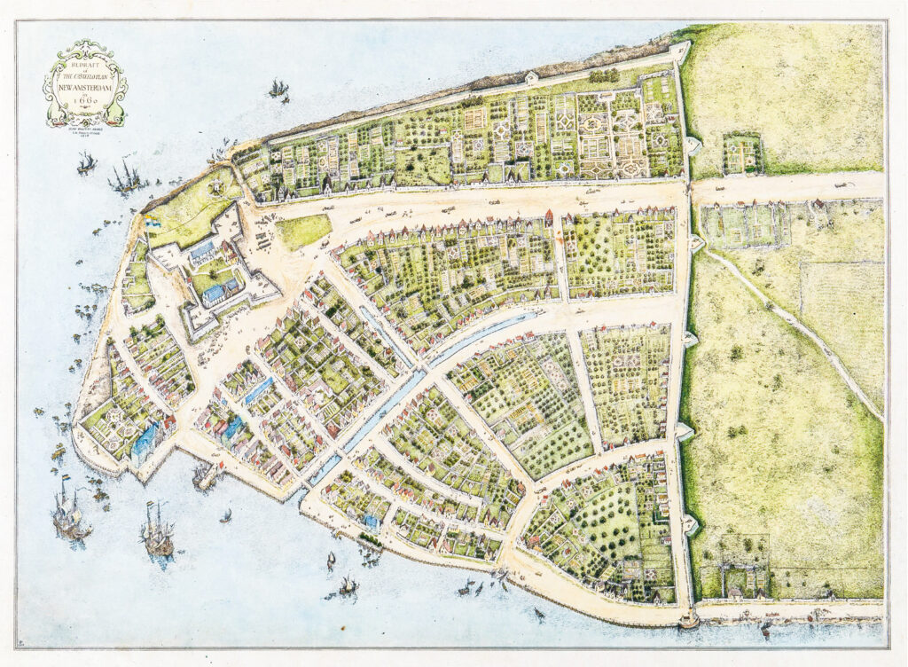
In taking over New Netherlands, the English did not expel any of its residents or seize their property, and they even permitted a series of Dutch mayors in New York City. As a result, the Dutch maintained a cultural and linguistic presence, with words like “cookie” and “coleslaw” creeping into the American vernacular. Their distinct architectural style also lived on, as did place names, such as Brooklyn (Breuckelen), Harlem (Haarlem), Coney Island (Conyne Eylandt) and Broadway (Breede Wegh). The street pattern of lower Manhattan below Wall Street, along with that of Kingston and Albany, New York stayed largely intact.7

Dutch to English to Dutch to English:

Dutch  Rule: 1626 to 1664
English Rule: 1664-1783
Dutch Rule: February 1673-November 1674
England Rule: 1674 until American Revolution.

Town Names will show up in a variety of historical documents for the current state of New York:

  • New Netherlands, now as far north as current Albany, New York; as far south as to include New Jersey; to Cape Henlopen, Delaware; and as far east as the Connecticut River. Would become British Colony of New York until American Revolution.
  • Fort Orange, New Netherlands, now Albany, New York
  • New Amsterdam, New Netherlands, now Lower Manhattan, New York
  • Fort Amsterdam, New Netherlands, now Lower Manhattan, New York
  • Esopus, New Netherlands, now Ulster County, New York
  • Wiltwyk, New Netherlands, now Kingston, New York
  • Nieuw Dorp, New Netherlands, now Hurley, New York
  • Beverwijck, New Netherlands, now Albany, New York
  • New Orange, New Netherlands, now New York, New York
  • Swaenenburgh, New Netherlands, now Kingston, New Yorkl

The British Colonies 1664-1774 Map

After the British took over New Netherlands, it was called the Province of New York, broken down into the British Colonies. Below are the Colonies in order:

  • Virginia – 1607
  • New York – 1626
  • Massachusetts Bay – 1630
  • Maryland – 1633
  • Rhode Island – 1636
  • Connecticut – 1636
  • New Hampshire – 1638
  • Delaware – 1638
  • North carolina – 1653
  • South Carolina – 1663
  • Ne Jersey – 1664
  • Pennsylvania – 1682
  • Georgia – 1732

Below is an interesting map showing state line changes [Virginia and north] and dates.  Pre-USA, it’s often called Colonial America

Province of New York, 1664-1777

Colonial America 1664-17778

Fun tidbit: “In 1664, the English, who conquered New Netherlands, called the Dutch Jan Kees (John Cheese) pronounced Yankees, which name became associated not only to the Dutch of New York, but to all New Englanders and hence to all northerners (and internationally to all Americans).”

Advertisement:

Citations:

  1. Henry Hudson - Speculative portrait from Cyclopedia of Universal History. Public Domain, https://commons.wikimedia.org/w/index.php?curid=461792.
  2. 19th-century Illustration Halve Maen In the Hudson river in 1609. Public Domain, https://com- mons.wikimedia.org/w/index.php?curid=10553272.
  3. Map of two North American voyages of Henry Hudson. Route of first voyages shown in red, second in purple. Credit: Base map used: http://commons.wikimedia.org/wiki/File:Topograph- ic30deg_N30W60.png, uploaded by User:Koba-chan. Rest of the work was that of the upload- er. Author: Jon Platek Usage Terms: Creative Commons Attribution-Share Alike 3.0. License: CC BY-SA 3.0. License Link: http://creativecommons.org/licenses/by-sa/3.0.
  4. Earliest Picture of Fort Amsterdam on Manhattan. Circa 1630. By [Not specified in source material] - NYPL, Public Domain, https://commons.wikimedia.org/w/index.php?curid=2386702
  5. Redraft of the Castello Plan of New Amsterdam in 1660. By John Wolcott Adams (1874–1925) and I.N. Phelps Stokes (1867–1944) - New-York Historical Society Library, Maps Collection, Public Domain, https://commons.wikimedia.org/w/index.php?curid=2081061
  6. Firth Haring Fabend, New Netherland in a Nutshell: A Concise History of the Dutch Colony in North America, 2012.
  7. Jesse Greenspan, The Dutch Surrender New Netherland, 350 Years Ago, 08 September 2014.
  8. Province of New York, 1664-1777 By Kmusser. CC BY-SA 2.5, https://commons.wikimedia.org/w/index.php?curid=1310243

Disclosure:
The family Information was retrieved from a variety of family trees, webgens and family stories. I will note citations as appropriate and hope the information assists you in your research, but please do not use this as proven evidence. Feedback is welcome!

Pat Burns. Copyright © 2024. All Rights Reserved.
Facebook
Twitter
LinkedIn

Leave a Reply

Your email address will not be published. Required fields are marked *