From this point forward in my posts there will be several references to property deeds being transferred to and from the family using Township or Precincts, which use a grid system, sections and subdivisions of a section.
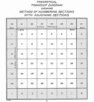
The existence of section lines made property descriptions far more straightforward than the old metes and bounds system. Or as we’ve seen, marks on the old Oak Tree. In 1785, the U.S. Congress passed an Ordinance (Land Ordinance of 1785) that provided lands outside the then-existing states could not be sold, otherwise distributed, or opened for settlement prior to being surveyed. The standard way of doing this was to divide the land into sections. An area six sections by six sections would define a township. Within this area, one section was designated as school land. As the entire parcel would not be necessary for the school and its grids, the balance of it was to be sold, with the monies to go into the construction and upkeep of the school.
I’m hoping this will be a quick way for you to understand the meaning behind the property descriptions.
Townships are subdivided into 36 Sections. Each Township is six miles by six miles and contain 36 square miles, each one forming a section. See numbering system below. You will see Section one starts on the Northeast corner with 36 ending on the Southeast corner. The example to the right shows the township centered, with the adjoining township sections on the north, east, south and west of the diagram.
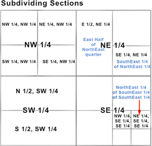
Sections are further divided into quarters. These are the northeast, northwest, southeast and southwest quarters. Each of these usually contain 160 acres. These quarters are then further divided into quarters, which are then 40 acres. The smallest quarter is given followed by the largest quarter, then the section, and then the township and range. For example, the NE 1⁄4, SW 1⁄4, T.5S.,R.7E.
- Diagram of survey township. By The image was done by the US Interior Bureau of Land Man- agementThis image is a work of a Bureau of Land Management* employee, taken or made as part of that person’s official duties. As a work of the U.S. federal government, the image is in the public domain in the United States.*or predecessor organization – The image was trans- ferred from the en.wiki. If necessary, it could be found here., Public Domain, https://commons. wikimedia.org/w/index.php?curid=17768151