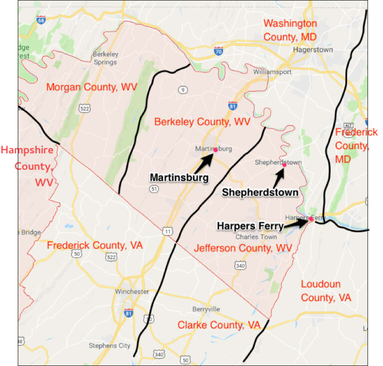
Martinsburg, Berkeley County, West Virginia
Orange County, Virginia, now Martinsburg, Berkeley County, West Virginia, is where John Van Metre (Jan Joosten Van Meteran, grandson of the Jan Joosten immigrant and also known as John Van Metre the Indian Trader), and his family finally settled in 1735. He was one of the first settlers in Berkeley County and also known as John of Berkeley, and John the first of Berkeley. He obtained the land through his Virginia Land Grants.
Martinsburg was not founded until 1778, but the history of the area goes back much farther as you will read in the History of Berkeley County below. In 1778 during the American Revolutionary War, Founder Major General Adam Stephen named the gateway town to the Shenandoah Valley along Tuscarora Creek in honor of Colonel Thomas Bryan Martin, a nephew of Thomas Fairfax, 6th Lord Fairfax of Cameron. You can read more about Lord Thomas Fairfax in my post Virginia Land Grants.
The first United States post office in what is now West Virginia was established at Martinsburg in 1792, still part of Virginia.
The Baltimore and Ohio Railroad (B&O) reached Martinsburg in 1842 and rebuilt after the American Civil War.
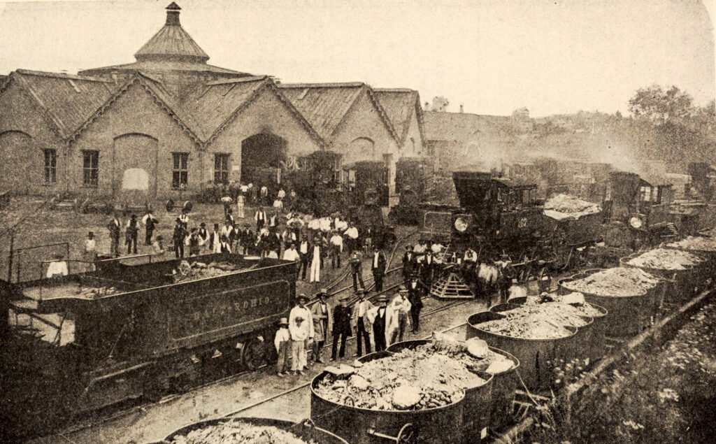
The Baltinore and Ohio’s Martinsburg Shops three years before the Civil War.1
Table of Contents
When we visited Martinsburg, in July 2017, we visited and were warmly welcomed by the Welcome Center and were told that the original Van Metre settlers were buried at what is now a campground. Since the original markers were most likely wooden crosses, none remain and all you’ll see are campers parked in the area.
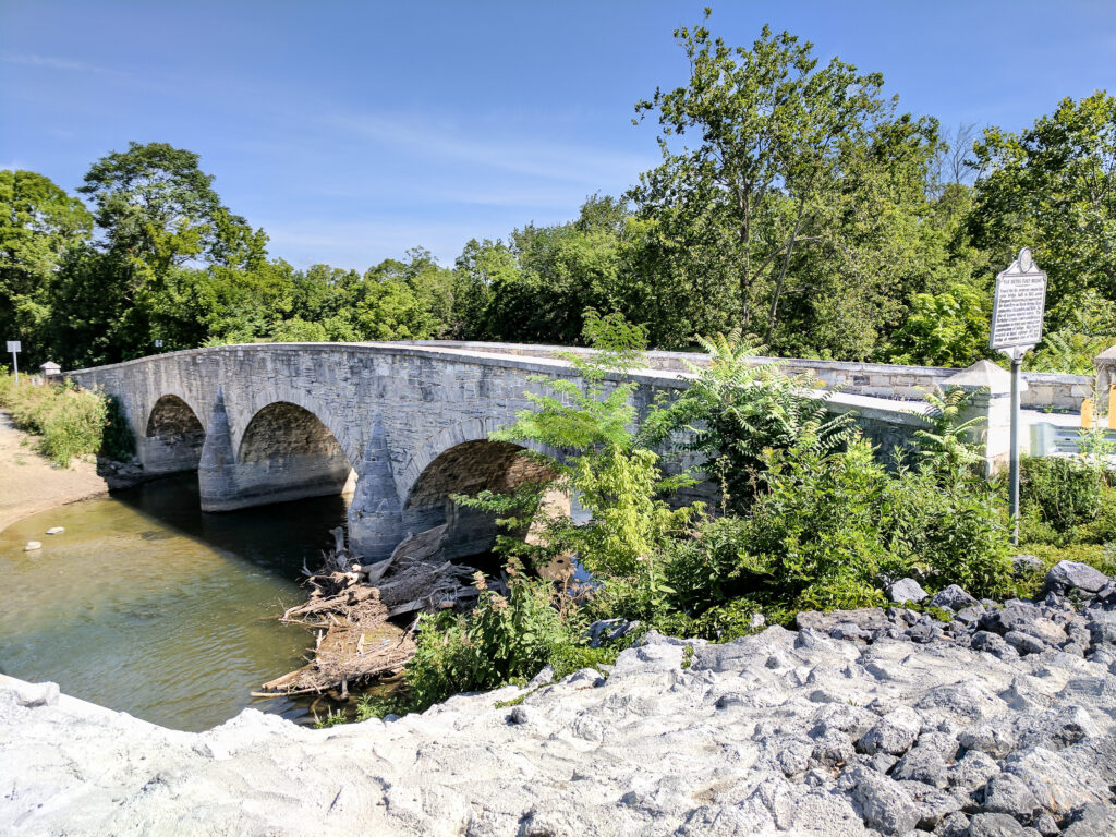
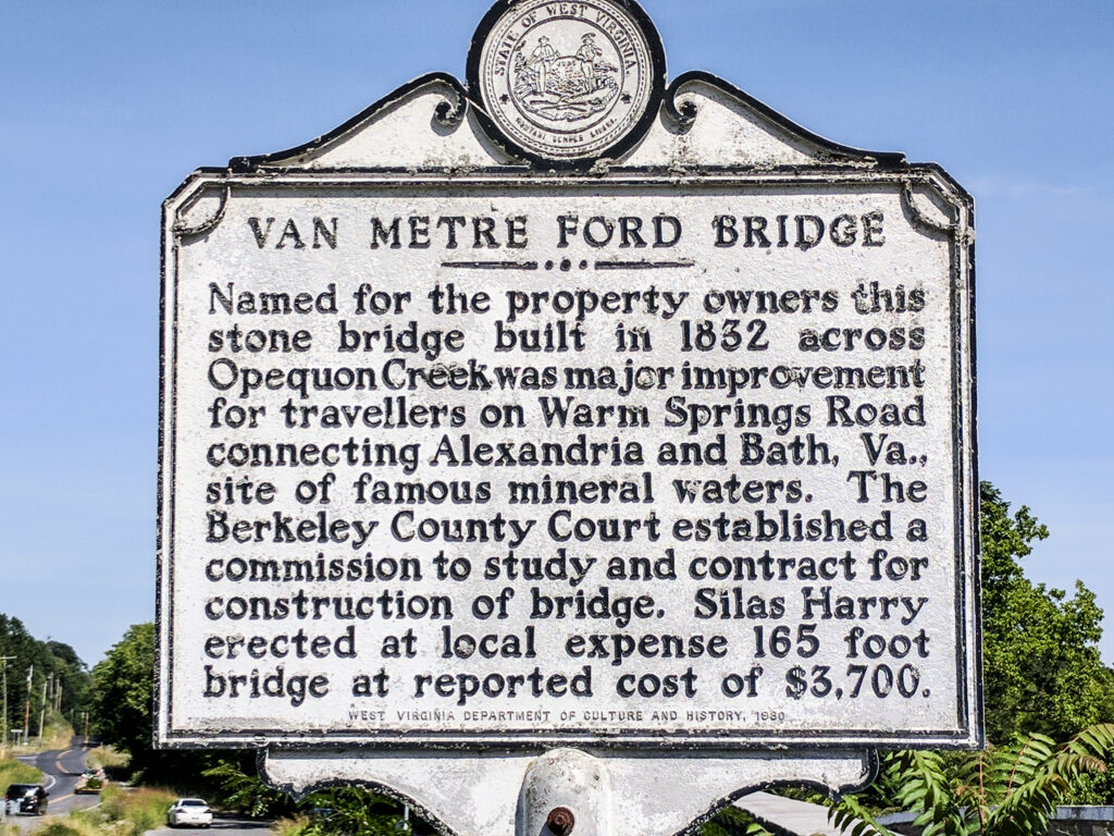
300 acres were later bequeathed to John Van Metre’s daughter, Rebecca (Van Metre) Hedges that was situated on the Warm Springs road. This was where in 1832 the Van Metre Ford Bridge was built that spans the Opequon creek near present Route 36, on the old road from Alexandia, Virginia to the Warm springs. This bridge is now a historical site and is called the Van Metre Stone Arch Bridge or Van Metre Ford Bridge. it is the second oldet bridge in West Virginia and has been replaced by a more modern bridge. It is now only open to foot traffic. Across the street we found two lone tombstones with the Van Metre name. One was illegible, but the second one was for William B. Van Metre who died in 1865 (I think, that may have been a birth year…it was difficult to read).
Although the descendants I am following have left the area, many of the descendants stayed in the area and it’s full of Van Metre history. There are still many descendants of John Van Metre living in the area.
History of Berkeley County
County Place Name Changes
As noted, John Van Metre acquired the land in Berkeley County in 1730. However, it was not Berkeley County until 1772. Below is the timeline of Place Name Changes for Berkeley County.
- 1721 – Spotsylvania County, Virginia was formed out of Essex, King and Queen and King William counties.
- 1734 – Orange County, Virginia was formed out of Spotsylvania County, Virginia.
- 1743 – Frederick county, Virginia was formed out of Orange County, Virgnia.
- 1772 – Berkeley County, Virginia was formed out of Frederick County, Virginia.
- 1801 – Jefferson County, Virginia was formed out of Berkeley County, Virginia.
- 1820 – Morgan County, Virginia was formed out of Berkeley County, and Hampshire County Virginia.
- 1867 – Berkeley and Jefferson County were the last two counties to transfer to the state of West Virginia.
–
For those researching your ancestry, these dates are important in order to know where to go to find records of your ancestors.
Berkeley county was named in honor of Norborne Berkeley, Baron de Botetourt, a royal governor of Virginia. Adam Stephen, Berekeley County’s first sheriff, laid out the county seat along Tuscarora Creek and named it Martinsburg in honor of his friend, Col Thomas Bryan Martin.
The History page of Berkeley County, West Virginia website has a short, but interesting, video of the changes of Berkeley County and the surrounding area, beginning in 1730.
History of Berkeley County, West Virginia
The following [edited] excerpt is from the book History of Berkeley County West Virginia by Willis F. Evans2
As Jefferson County was part of Berkeley until 1801 and Morgan County was taken from Berkeley in 1820 the History of Berkeley County needs to include the events transpiring within these two counties up to the time of their formations.
This section first became known to the white man in about the year 1660 when John Lederer, an explorer employed by Sir William Berkeley, colonial governor of Virginia, visited it.
On this expectation he crossed the Blue Ridge in the vicinity of what is now Harper’s Ferry, explored the valley there and penetrated to the west as far as the3 valley of the Cheat River. He was probably the first white man to set foot upon the soil of Berkeley County.
In 1725, John Van Matre (as the name was written at that time), a member of a prominent family of New York and Holland, traversed this county. He crossed the Cohongoruton (Potomac) River at what is now Shepherdstown, and penetrated to the Wapatomacka (South Branch) River.
To Morgan Morgan belongs the honor of building the first cabin home in Berkeley County and, in fact, in all of wha tis now West Virginia. In 1726, he settled on Mill creek at what is now the town of Bunker hill. He was a native of Wales, having migrated to Pennsylvania at an early period and then to the valley of Virginia. He was an Episcopal minister and established the Episcopal Church at Bunker Hill. He was afterward appointed one of the King’s Gentleman Justices for Berkeley County.
The first emigrants to come to Berkeley County in a body was in 1727, when a number of persons from Pennsylvania crossed the Coongoruton (Potomac) at the “Old Pack horse Ford”, two miles below Shepherdstown. This section with its gray limestone cliffs bordering the river at this place, reminded them so much of their old home in Germany that they decided to stop here and begin a settlement. They named their settlement New Mecklenburg for the old town in Germany. This is the oldest town in West Virginia. Thirty four yers later (1761), the Virginia Assembly by legislative enactment established a town there and named it Shepherdstown in honor of Thomas Shepherd, who laid it out.
John Van Metre and his brother Isaac secured a tent from Governor Gooch, then Colonial Governor of Virginia, for forty thousand acres of land in 1730. John settled on the Opequon in the vicinity of Vanclevesville (about 3 miles Southeast of Martinsburg). Johns brother Isaac Van Metre proceeded west to the South branch [Old Fields] in Hardy County and each became the progenitor of large families in either section. A large portion of this grant included land in what is now Berkeley, Jefferson, Morgan, Hampshire and hardy Counties, West Virginia and Frederick County, Virginia.
The next large body of emigrants to come to this section was that of Joist Hite, with his family, in 1732. In that year he purchased from John Van Metre a portion of the 40,000-acre tract granted to him by Governor Gooch. This portion was located in Frederick County. Those accompanying Hite were his sons-in-law, George Bowman, Jacob Chrisman and Paul Foreman with their families; Robert MacKay, Peter Stephens, Robert Green, William Duff and others. The party, comprising sixteen families in all, removed from the vicinity of what is now York Pennsylvania, crossed the Cohongoruton about two miles above Harper’s Ferry, and proceeded to about five miles south of Winchester. There they founded a settlement, or colony, on what is now the Valley Pike. They cut their way through the forest as they went and a part of this is now the Winchester Pike through Berkeley County which was formerly known as the Great Winchester Road. None of these settled in what is now Berkeley County but this is mentioned here as an enterprise of this nature induced others to make their homes in this section.
In 1734 Richard Morgan obtained a grant for a tract of land in the neighborhood of what is now Shepherdstown and from him the famous Morgan Springs in Jefferson County are named. It is now owned by the Morgan’s Grove Fair Association, at which place a great annual agricultural fair is held, and this spring furnishes water for thousands of visitors at this place.
Among the first settlers to New Mecklenburg (Shepherdstown) and in the vicinity were: Thomas Shepard, Jacob Van Metre, William Stroop, James Foreman, John Lemon, Richard Mercer, Thomas Forester, William Forester, John Wright, Samuel Taylor, Robert Stockton, Robert Buckles, Van Swearingen, Richard Morgan, William Foster, Israel Friend, Thomas Swearingen, Edward Sucas, Jacob Hite, Edward Mercer, and John Taylor.
Robert Harper settled nearer where Harper’s Ferry now stands and the ferry established across the Potomac at that place some years later was named for him. These settlements were made about the year 1734-5
Another patent for 13,000 acres of land was granted by the Colonial Governor of Virginia. The owner of this land by gambling and sporting had become deeply involved in debt. To satisfy his creditors, it was sold under the hammer at Williamsburg, then the capital of Virginia. General Washington happening to be present and, who knew of it, persuaded Ralph Wormley to buy it, which he did. He had been imbibing too freely of spirits and, after reflection, was disgusted with his purchase and wished to get rid of it. Washington still advised him to retain it as he thought it would develop into a valuable piece of land, and if he was still dissatisfied with his purchase he (Washington) would take it off his hands. This led Mr. Wormley to still retain it and it did develop into a valuable piece of property, as Washington had predicted, had his children known how to take care of it, but it passed into other hands. Much of this tract was in Berkeley County in that portion which is now Jefferson County.
As noted, John Van Metre settled on the Opequon about 3 miles Southeast of Martinsburg. John Evans settled on the Opequon near where the State Road crosses it from Martinsburg to Charles Town.
John Boyd settled at the east base of North Mountain in the vicinity of Tuscarora Creek. All these settlements were made prior to the year 1740. The record of other settlements are meager, but they must have been numerous for at the outbreak of the French and Indian War in 1754, Colonel George Washington raised three hundred men to fight the Indians and many of these were collected from Berkeley County.
It is evident that the Quakers were among the first inhabitants. These the Indians never molested and they were invited to make settlements in the section of what is now Berkeley County.
Early Explorations and Settlements
The History of Berkeley County, West Virginia, written by Willis F. Evans3 provided an interesting account of the early explorations and settlements of the area (excerpt below).
As Jefferson County was a part of Berkeley until the year 1801, when by an act of the Virginia Assembly it was made a separate county,, and Morgan County was taken from Berkeley in 1820 and made a separate county by the same process, the history of Berkeley County must needs include the events transpiring within these two counties up to the time of their formation. The original Berkeley County included all the territory in what is now the “Eastern Panhandle”, and extended from the Potomac to the Shenandoah rivers on the north and east, to the confines of Hampshire County.
This section first became known to the white man in about the year 1660 when John Lederer, an explorer employed by Sir William Berkeley, colonial governor of Virginia, visited it. On several occasions, prior to this time, he had made journeys to the Shenandoah valley to the southern part, but in this year he had decided to see what country lay in the northern section of the valley. On this expedition he crossed the Blue Ridge in the vicinity of what is now Harper’s Ferry, explored the valley there and penetrated to the west as far as the valley of the Cheat River. He was probably the first white man to set foot upon the soil of Berkeley County.
A few years later came John Howard and his son, who, on a journey to this section, discovered the valley of the South Branch of the Potomac; continued across the Allegheny mountains, and when they reached the Ohio River, killed a large buffalo, or bison, removed its hide, and with the help of ribs of wood, made a rude boat in which they set sail on that river and floated with the current to New Orleans.
Previous to this time Robert Cavalier La Salle had discovered the Ohio and Mississippi and planted a fort at the mouth of the latter and called it Fort New Orleans. These two, father and son, were arrested as suspicious characters. They were sent to France, tried, but as nothing criminal was found against them they were released and then returned to England. Lord Fairfax, then residing in England, chanced to hear of Howard’s discoveries in the Shenandoah and South Branch valleys and in an interview with him learned of the fertility of the soil and the beauty of the country and determined to gain possession of it for himself.
In those days this section was covered by almost impenetrable forests and people were slow to take advantage of its natural resources, and over sixty years had passed away before another white man traversed this trackless wilderness. In 1725, John Van Matre (as the name was written at that time), a member of a prominent family of New York and Holland, traversed this county. He crossed the Cohongoruton (Potomac) River at what is now Shepherdstown, and penetrated to the Wapatomacka (South Branch) River where John Howard had been many years before. He [ John Van Matre] was an Indian trader; when in this section resided with the Delawares on the Susquehanna River in Pennsylvania. he wished to trade with the Catawabas also, and on his journey happened to traverse this valley. He was so charmed with it that when he returned home he advised his sons that if they ever migrated to Virginia, to obtain land on the South Branch as the “Trough” contained the finest land he had ever seen. On one occasion he led an expedition of Delawares against the Catawabas. They met at where the Pendleton County court house now stands, and a fierce battle was fought which went against the Delawares. John Van Matre was the ancestor of the Van Metres which later settled in Berkeley County on the Opequon and in Hardy County on the south Branch.
In 1716 Governor Spottswood, colonial governor of Virginia, organized a party of thirty emn; provisioned and equipped them at Williamsburg—which was then the captial of Virginia—and proceeded at the head of this party to make explorations in the Shenandoah valley. The party crossed the Blue Ridge and the Shenandoah valley and reached the summit of the Alleghenies. The party returned to Williamsburg and the governor organized waht he termed the Trans-Mountain Order, or “Knights of the Golden Horseshoe”. He gave to each on who had accompanied him a miniature horseshoe which bore the inscription “Sic jurat transcudere montes”, or “Thus he swears to cross the mountains”. All others who would comply with the terms of the inscription were given one.
Although this expedition did not reach this section, such acts as these let to the settling of the valley at an an early date.
To Morgan Morgan belongs the honor of building the first cabin-home in Berkeley County and, in fact, in all of what is now West Virginia. In 1726, he settled on Mill creek at what is now the town of Bunker Hill. He was a native of Wales, having migrated to Pennsylvania at an early period and from thence to the valley of Virginia. He was an episcopal minister and established the Episcopal Church at Bunker Hill. He was afterward appointed one of the King’s Gentleman Justices for Berkeley County.
The first emigrants to come to Berkeley county in a body was in 1727, when a number of persons from Pennsylvania crossed the Cohongoruton (Potomac) at the “Old Pack-horse Ford”, two miles below [what is now] Shepherdstown. This section, with its gray limestone cliffs bordering the river at this place, reminded them so much of their old home in Germany that they decided to stop here and begin a settlement. They named their settlement New Mecklenburg for the old town in Germany. This is the oldest town in West Virginia. Thirty-four years later (1761), the Virginia Assembly by legisative enactment established a town there and named it Shepherdstown in honor of Thomas Shepher [husband of Elizabeth (Van Metre) Shepherd], who laid it out.
West Virginia
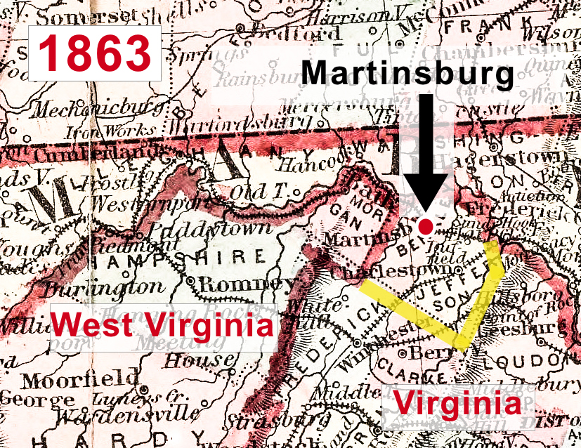
West Virginia State (originally planned to be called the State of Kanawha, but ultimately named West Virginia) was officially formed June 20, 1863. Berkeley County and Jefferson County was not included and they would not be part of West Virginia until 1867.4
West Virginia succeeded from Virginia due to Anti-Slavery sentiments. Setting the state’s boundaries was the most challenging issue facing the state’s founders, even more so than slavery. The new state had to balance the desire for political cohesion against those of security in light of the ongoing war, which was being waged in and around western Virginia.
Of grave importance was the need to keep the Baltimore and Ohio Railroad within union hands. This vital rail link was the only direct railway connecting Washington with the western states. There was the possibility that the Confederacy might win the war, and the north wanted to be sure that the B&O remained within the Untied States after a peace had been negotiated, should that be necessary. It was decided, that the Potomac counties as far east as the Harper’s Ferry crossing be included within the new state.
In the end Congress approved a state consisting of 48 counties. Jefferson, Berkeley, and Frederick Counties were given the option of joining the new state after Confederate control had ended. West Virginia entered the Union in 1863. Following referendums in 1866, Jefferson and Berkeley Counties were transferred to West Virginia, effective in 1867. Frederick County never held a referendum. The transfer of the two eastern panhandle counties represents the final boundary adjustment in Virginia’s history.
Harpers Ferry
Harpers Ferry is a historic town now located in Jefferson County, West Virginia. It is located in the lower Shenandoah Valley and situated at the confluence of the Potomac and Shenandaoh rivers, where the states of Maryland, Virginia and West Virginia meet.
The town was formerly spelled Harper’s Ferry with an apostrophe, so named because n the 18th century it was the site of a ferry service owned and operated by Robert Harper. Changed in 1891 to remove the apostrophe by 1891.
In 1733, Peter Stephens, a squatter, settled on land near The Point, the area where the Potomac and Shenandoah Rivers meet, and established a ferry from Virginia (now West Virginia) to Maryland, across the Potomac River.
Robert Harper, from whom the town takes its name, was born in 1718 in Oxford Township near Philadelphia, Pennsylvania. Since he was a builder, kHarper was asked by a group of Quakers in 1747 to build a meeting house in the Shenandoah Valley near the present site of Winchester, Virginia. Traveling through Maryland on his way to the Shenandoah Valley, harper–who was also a millwright–realized the potential of the latent water power from the Shenandoah and Potomac Rivers at an easily accessible location. He paid Stephens 30 guineas for his squatting rights to the ferry, since the land actually belonged to Lord Fairfax.
Harper then purchased 126 acres of land from Lord Fairffax in 1751. In 1761, the Virginia general Assembly granted him the right to establish and maintain a ferry across the Potomac, even though a ferry had already been functioning since before Harper arrived. In 1763, the Virginia General Assembly established the town of Shenandoah Falls at Mr. Harpers Ferry.” Harper died in October 1782 and is brie dint he Harper Cemetery.
On October 25, 1783, Thomas Jefferson visited Harpers Ferry as he was traveling to Philadelphia and passed through harpers Ferry with his daughter Patsy. Viewing “the passage of the Potomac through the Blue Ridge from a rock that is now named for him as Jefferson’s Rock, he called the site “perhaps one of the most stupendous scenes in nature” and stated “This scene is worth a voyage across the Atlantic.” The town was one of his favorite retreats, and tradition says that much of his Notes of the state of Virginia was written there. Jefferson County, in which Harpers Ferry is located was named for him on its creation in 1801.
George Washington, as president of the Patowmack Company, which was formed to complete river improvements on the Potomac River and its tributaries, traveled to harpers Ferry during summer 1785 to determine the need for bypass canals. [1785 was 4 years before he became the first U.S. President]. Following Washington’s familiarity with the area led him to propose the site in 1794 for a new U.S. armory and arsenal, some of his family moved to the area. His brother Charles washington, who founded the nearby Jefferson County town of Charles Town, and his great-great-nephew, Colonel Lewis Washington, who was held hostage during John Brown’s raid in 1859, both moved to the area.
The Civil War was disastrous for Harpers Ferry, which changed hands eight times between 1861 and 1865. Because of the town’s strategic location on the railroad and at the northern end of the Shenandoah Valley, both Union and Confederate troops moved through Harpers Ferry frequently. This is also the location of abolitionist, John Brown’s raid to initiate an armed slave revolt in 1859. He was later captured and found guilty of treason against the Commonwealth of Virginia and was hanged on December 2, 1859.
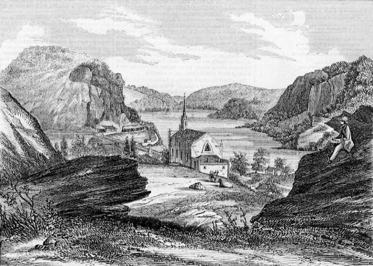
Harpers Ferry – View from Jefferson Rock in 1854.7
Another historic town in West Virginia is Shepherdstown. As noted, originally the town was called New Mecklenburg. One of the settlers who established Mecklenburg was Thomas Shepard, husband of Elizabeth (Van Metre) Shepard, daughter of John Van Metre. In our 2017 trip, we visited the historic town of Shepherdstown. See my post on Shepherdstown.
Citations and Attributes:
- The Baltimore and Ohio's Martinsburg Shops three years before the Civil War. By Baltimore and Ohio employees magazine;Baltimore and Ohio Railroad Company - https://www.flickr.com/photos/internetarchivebookimages/14575208137/Source book page: https://archive.org/stream/baltimoreohioemp03balt/baltimoreohioemp03balt#page/n539/mode/1up, No restrictions, https://commons.wikimedia.org/w/index.php?curid=44257208 (Accessed 7 Apr 2023).
- Evans, Willis F. History of Berkeley County West Virginia, original ©1928, reprint ©2001, pages 17-20, reviewed at google books at https://www.google.com/books/edition/History_of_Berkeley_County_West_Virginia/7oJeb5AHmhkC?hl=en&gbpv=1&dq=The+next+large+body+of+emigrants+to+come+to+this+section+was+that+of+Joist+Hite,+with+his+family,+in+1732.+In+that+year+he+purchased+from+John+Van+Metre&pg=PA19&printsec=frontcover (Accessed 7 April 2023).
- Evans, Willis F., History of Berkeley County West Virginia. 1928, p. 17-20.
- Phillips, Karl R., How Virginia Got Its Boundaries, 1999. Reviewed online at http://www.virginiaplaces.org
- West Virginia Counties. By Jm0371 (talk) / Jm0371 at English Wikipedia - Own work (Original text: self-made), Public Domain, https://commons.wikimedia.org/w/index.php?curid=30332641 (Accessed 7 April 2023).
- Colton's map of Virginia, Maryland & Delaware, first published by Johnson and Ward, New York, 1863. Public Domain, https://commons.wikimedia.org/w/index.php?curid=59785079. Image rendered for tone and sharpness by Gwillhickers (altered).
- View of harpers Ferry from Jefferson Rock in 1854 - https://commons.wikimedia.org/wiki/File:View_from_Jefferson_Rock.jpg#/media/File:View_from_Jefferson_Rock.jpg (Accessed 7 April 2023).
2 Responses
Thank you for organizing all of the Martinsburg Van Metre information. My husband and I are hoping to visit there later this fall!
You’re Welcome. If you can, visit the visitor center. Although it was a holiday, they arranged for us to visit the archives. There is a lot of information on the Van Metre family. My only regret is we just didn’t have enough time. Safe travels and enjoy your visit.