Virginia Land Grants
Many of the early settlers of Virginia obtained their land from Virginia Land Grants,
Who Controlled the granting of all this land?
The answer is a sequence of royal laws. In earliest times, the English crown controlled the granting of land, normally through each colony’s government. Basically the King claimed ownership of the colonial land and distributed it according to a variety of laws subject to his approval. No matter that the land was already occupied by native tribes. What land could not be purchased could be taken by treaty or by force.
Headright System
A headright refers to a legal grant of land given to settlers during the period of European colonization in the Americas. Headrights are most notable for their role in the expansion of the Thirteen Colonies, the Virginia Company gave headrights to settlers, and the Plymouth Company followed suit.
The Northern Neck Proprietary
The King had granted the Northern Neck Proprietary to seven of his supporters in 1649 (officially 1660). The rest of the land would be granted by the Governors of the time. The Van Metre Virginia Land Grants were dated June 17, 1730 granted to them by Governor Sir William Gooch and were assumed to be outside of The North Neck Proprietary. Since no surveys had been done at that point.
The Kings Grant
The Northern Neck Proprietary, also called the Northern Neck land grant, Fairfax Proprietary, or Fairfax Grant, was a land grant first contrived by the exiled English King Charles II in 1649 and encompassing all the lands bounded by the Potomac and Rappahannock Rivers in colonial Virginia. This constituted up to 5,000,000 acres of Virginia’s Northern neck and a vast area northwest of it.
The original basis for the grant dates back to the English Civil War, which was won by the Parliamentary party under Oliver Cromwell. John Culpeper was on the side of the King. Charles I. He elevated Colepeper to the peerage in 1644 and made him the first baron Colepeper of Thoresway, or John First Lord Colepeper.
Table of Contents
Charles I was the loser in the civil war. The victorious Puritans executed the king on January 30 1649 (1648 old style calendar) and controlled England for a decade. After the king’s execution, the son of Charles I declared himself to be the King Charles II, but had to flee to France with his few supporters. One of those supporters was John First Lord Culpeper. While in exile in France, Charles II had limited resources to reward his key supporters and retain their allegiance. The king-in-exile did claim that he retained the right to govern the colonies across the Atlantic Ocean in North America, and could dispose of his land there.
In September 1649, King Charles II of England granted to seven Englishmen all of Virginia between the Rappahannock and Potomac Rivers as a Proprietary (Colony). The proprietors thought little of their grant since Charles II, due to political struggles in England, was a king without a kingdom.
The grant became actual in 1660 when Charles was restored to the English throne. One of the seven grantees was John Colepeper, 1st Baron Colepeper of Thoresway (1600-1660). By 1681 5/6th Control of the Proprietary came to one man, his son Thomas Colepeper, 2nd Baron Colepeper, as he had purchased the rights of other patentees and who also received a new patent issued by King James II in 1688. Lord Colepeper died the following year. His 5/6th share of the proprietary was inherited by his daughter Catherine Culpeper and her husband Thomas Fairfax, 5th Lord Fairfax of Cameron.
While some of the original proprietors’ rights had been lost, the collecting of taxes from settlers had been established through the efforts of their agents in Virginia and through Lord Fairfax himself to ensure that the proprietors received their income from their property. After Lord Fairfax died in January 1710, his son Thomas, the 6th Lord of Fairfax, inherited the title and his five-sixths shares in the Northern Neck. In May (the same year?), his grandmother died leaving the new Lord Fairfax her one-sixth share. Because he was only sixteen years old at the time, the affairs of the Proprietary fell to his mother, Lady Catherine Fairfax. When she died in 1719, the sixth Lord Fairfax came to control all six shares of the proprietary.
Fairfax relied on the income from his Virginia tract, both from the sale of land and the annual quit rents, paid by planters who settled in the Northern Neck. These rents were collected by his resident land agent, Robert Carter (1662-1732). In the fall of 1732, Fairfax read Carter’s obituary in the London monthly The Gentleman’s Magazine and was astonished to read of the vast personal wealth carter had accumulated, which included £10,000. in cash: this at a time when the Governor of Virginia was paid an annual salary of £200. Rather than appoint another Virginian to the position, Lord Fairfax arranged to have his cousin Colonel William Fairfax move in 1734 from Massachusetts to Virginia to serve as his resident land agent.
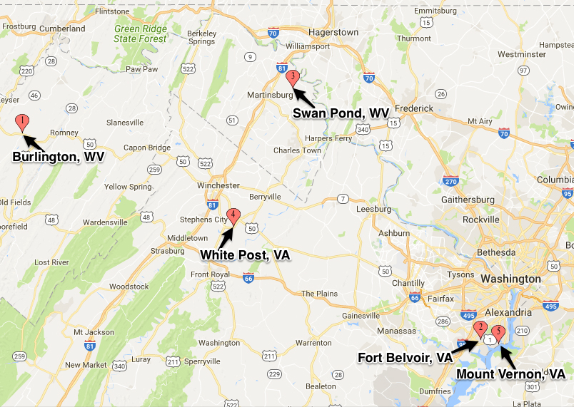
Sometime between 1735 and 1737 Lord Fairfax travelled to Virginia for the first time, to inspect and protect his lands. In 1738, about thirty farms were established as part of his 9,000 acre Patterson creek Manor near present-day Burlington, Mineral County, West Virginia.
Virginia Colony Grants
The Virginia officials in Williamsburg disputed the right of land agents employed by Lord Fairfax to sell land in the Shanendoah Valley. That triggered an official survey of the 1649 grant boundaries. Decisions in London finally defined the extent of the Fairfax grant in 1746 and the line between the headsprings of the Rappahannock and Potomac rivers was surveyed officially a year later.
The primary conflict involved the definition of the southern boundary of the grant (which stream was the Rappahannock River?), and responsibility for lands west of the Blue Ridge. One spur for Lord Fairfax to come to Virginia and fight for his claim was the colonial government’s land grants in 1730-1732, when Governor Gooch authorized settlement on 385,000 acres across the mountains. This included our Van Metre and Jost Hite Land Grants.
Survey of the Virginia Northern Neck 1736-1737
The description of the Northern Neck Grant “The boundaries of the patent beginning at the Chesapeake Bay, lied between the Potomac and the Rappahannock Rivers, crossing the Blue Ridge, or, rather passing through the gap at harpers Ferry, then with the Chongaluta [Potomac] to its source in the Allegany’s, then by a straight line crosses the great Northern Mountain and Blue Ridge to the headwaters of the Rappahannock, wherever that may be.”
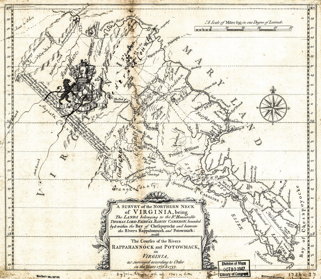
Survey of the Northern Neck of Virginia, 1736 & 1737.1
Lord Thomas Fairfax
Thomas Fairfax, 6th Lord Fairfax of Cameron was born 22 October 1693 and died 09 December 1781. He was a Scottish peer and the son of Thomas Fairfax, 5th Lord Fairfax of Cameron and Catherine, daughter of Thomas Colepeper, 2nd Baron Colepeper.
The only resident peer in late colonial America, Fairfax administered his vast Northern Neck Proprietary — a Virginia land grant dating back to 1649 — from his wilderness estate at Greenway Court, Virginia. Various place names in Northern Virginia and the Eastern Panhandle of West Virginia are named for him—most notably Fairfax County, Virginia.
Born in Kent, England at Leeds Castle — owned by his maternal Colpeper ancestors since the 1630s – Lord Fairfax succeeded to his title in 1709.
In 1719, Fairfax came into possession of the vast Colpeper family estates in Virginia’s Northern Neck Proprietary between the Rappahannock and Potomac Rivers. As noted above, which consisted of 5,282,000 acres. Struggling to keep up an expensive lifestyle and maintain Leeds Castle, Fairfax relied on the income from his Virginia Tract, both from the sale of land and the annual quite rents, paid by planters who settled in the Northern Neck.
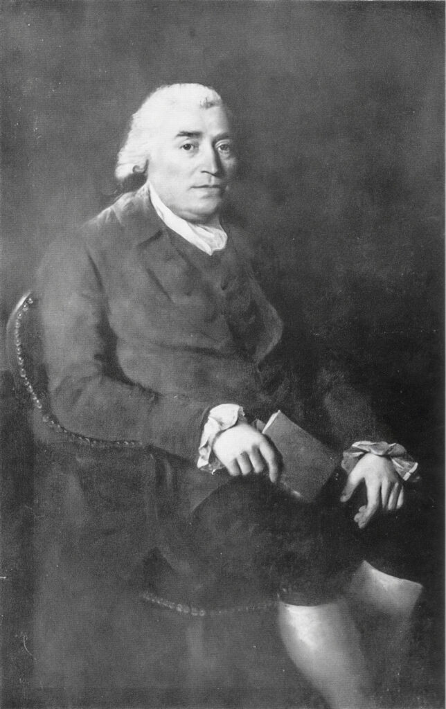
Lord Thomas Fairfax, 6th Lord Fairfax (1693-1781).2
These rents were collected by his resident land agent, Robert “King” Carter (1662-1732). In the fall of 1732, Fairfax read Carter’s obituary in the London monthly The Gentleman’s Magazine and was astonished to read of the vast personal wealth Carter had accumulated, which included £10,000 in cash: this at a time when the Governor of Virginia was paid an annual salary of £200. Rather than appoint another Virginian to the position, Lord Fairfax arranged to have his cousin Colonel William Fairfax move in 1734 from Massachusetts to Virginia to serve as his resident land agent.
Lord Fairfax traveled to Virginia for the first time between 1735 and 1737 to inspect and protect his lands. In 1738, about thirty farms were established as part of his 9,000-acre Patterson Creek Manor near present-day Burlington, Mineral County, West Virginia. The northwestern boundary of his Northern Neck Proprietary, which had been contested by the English Privy Council, was marked in 1746 by the Fairfax Stone at the headwaters of the North Branch Potomac River. Returning to America in 1747, he first settled at Belvoir (present-day Fort Belvoir), an estate which had been completed by Col Fairfax six years earlier. That year he also set aside land for his personal use at Swan Pond Manor (located near present-day Martinsburg, Berkeley County, West Virginia). [This is where John Van Metre [3] settled.] He then became active in developing his lands and collecting ground rents.
Fairfax was the only resident peer in the Thirteen Colonies. In 1748, he made the acquaintance of George Washington, then a youth of 16, a distant relative of the Yorkshire Fairfax family. Impressed with Washington’s energy and talents, Lord Fairfax employed him (Washington’s first employment) to survey his lands lying west of the Blue Ridge.
Fairfax, a lifelong bachelor, moved out to the Shenandoah Valley in 1752. At the suggestion of his nephew Thomas Bryan Martin, he fixed his residence at a hunting lodge at Greenway Court, near White Post, Clarke County. Here he and Martin lived together in a style of liberal hospitality, frequently indulging in the diversion of the chase [Fox Hunting]. He served as county lieutenant and as justice of the peace for Frederick County which then included Clarke County.
Though an avowed Loyalist, Fairfax kept quiet and was known to be close to Washington. He was never insulted or molested. Title to his domain, however, was confiscated during the hostilities by the Virginia Act of 1779. Less than two months after the 1781 defeat of the British army at Yorktown, the 88-year- old Fairfax died at his seat at Greenway Court. He was buried on the east side of Christ Church in Winchester, Virginia.
His brother, Robert Fairfax, became the 7th Lord Fairfax of Cameron. He died on July 15, 1793 without an heir so the Cameron title was left in abeyance. His cousin, Bryan Fairfax, 8th Lord Fairfax of Cameron, visited London in 1798 and claimed the title (although he never actually used the title once it was granted to him). He lived in the United States where he was a priest of the Episcopal Church, and a neighbor and friend of George Washington.
Van Metre Land Grants
John Van Metre and his brother, Issac, were given a 40,000-acre land grant dated 17 June 1730, as follows:3
Several Petitions being this Day offered to the Board for leave to take up Land on the River Sherrrando on the North West Side of the great Mountains Robt Carter Esqr Agent for the Proprietors of the Northern Neck moved that it might be entr’d that he in behalf of the sd pProprietors & within the Limits of their Grant & that it belonged Solely to the Proprietors to grant the sd Lands wch Motion at his request is entred & then the Board proceeded to the hearing the sd Petitions.
On reading at this Board the Petition of John Vanmeter Setting forth that he is desirous to take up a Tract of Land in this Colony on the West side of the great Mountains for the settlement of himself & Eleven Children & also that divers of his Relations & friends living in the Governmt of New York are also desirous to remove with their families & Effects to Settle in the same place if a Sufficient Quantity of Land may be assign’d then for that purpose & praying that ten thousand Acres of Land lying in the fork of Sherrundo River including the places called by the Names of Cedar Litch & Stony Lick and running up between the branches of the sd River to Compleat that Quantity & twenty thousand Acres of the land not already taken up by Robert Carter & Mann Page Esqrs or any other llying in the fork between the sd River Sherundo and the River Cahongaroota & extending thence to Opeckon & up the south branch thereof may be assign’d for the Habitation & Settlemt of himself his family & friends. The Governour with the advice of the Council is pleas’d to give leave to the sd John Vanmeter to take up the sd first mentioned Tract of ten thousand Acres for the settlement of himself & his family and that as Soon as the petitioner Shall bring on the last mentioned Tract twenty Families to inhabit or that this Board is Satisfied so many are ready to remove thither Leave be & it is hereby granted him for Surveying the last mentioned Tract of twenty thousand Acres within the limits above describ’d in so many Several Dividends as the petr & his sd partners shall think fit and it is further ordered that no person be permitted to enter for or take up any part of the afsd Land in the meantime provided the sd Vanmeter & his family & the said twenty other Families of his Relations and Friends do settle thereon within the Space of two Years according to his proposal.
Isaac Van meter of the province of West Jersey having by his petition to this Board Set forth that he & divers other German Families are desirous to settle themselves on the West Side the great Mountains in this Colony he the Petitioner has been to View the lands in those parts & has discovered a place where such Settlement may Conveniently be made & not yet taken up or possess’d by any of the english Inhabitants & praying that ten thousand Acres of Land lying between the Lands Surveyed for Robt Carter Esqr the fork of Sherundo River & the River Opeckon in as many Several Tracts or Dividends as shall be necessary For the Accomodation & Settlement of ten Families (including his Own) which he proposes to bring on the sd Land The Governour with the Advice of the Council is pleas’d to order as it is hereby Ordered that the sd Isaac Vanmeter for himself & his Partners have Leave to take up the sd Quantity of ten thousand Acres of Land within the Limits abovedescrib’d & that if he brings the above Number of Families to dwell there within two Years patents be granted him & them for the same in Such Several Tracts & Dividends as they shall think Fit & in the Mean time that the same be reserv’d Free from entry of any other person.
In the survey of Isaac Van Metre’s grant: “Survey extended from the north bank line of the Sherando river northward to the Operkon river then following its flow embracing the land and prairies, forests and streams and their sources lying betweixt thereof—said Operkon and ye said Sherando [Shenandoah]; Both lines showing monuments for courses and measures.”
Lord Fairfax’s grant, from the crown ante-dated these and all other grants; but at that date it was assumed that the great Colepeper Grant, which had been curtailed to the Northern Neck, then Fairfax’s grant, did not extend beyond the Blue Mountains, and that the Potow-mack [Potomac] River was wholly East of these mountains; and it was not until about 1736-1737, that Lord Fairfax, the father of Lord Thomas through his agents, discovered by survey that his grant covered an empire, more than he supposed. Below is the 1736-1737 Fairfax Survey. The Pink area is the boundaries mentioned in John Van Metre’s Grant. Until the survey of 1736-1737 it was assumed (even by Fairfax himself it is believed) that the Fairfax Grant only extended to the Blue Mountains (East of the Shenandoah River). As you can see the Van Metre Grants fall within the boundaries of the Fairfax Survey, but on the West side of the Blue Mountains.
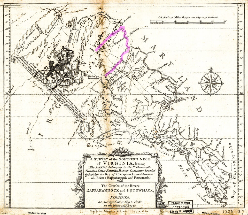
Survey of the Northern Neck of Virignia, 1736 & 1737.4
The pink area is the outline of the Shenandoah River, up to the Potomac and down the Opequon which is the boundaries in John Van Metre’s Grant.
Jost Hite Land Grant
Now to complicate things further, the Jost / Joist Hite Grants come into play. Jost Hite through the influence of Governor Penn, obtained a conditional grant from the Virginia council in 1731, for 100,000 acres of land, to be located West of the Great Mountains [Blue Mountains], not already granted—upon which he was to locate forty families, within a certain time. The number was reduced to twenty families. Joist Hite had at least three other partners, Robert Duff, William Green and Robert McKay. Another member of the group, Peter Stephens, was a surveyor.
Hite brought sixteen families with him. Some of the sixteen families were Joist Hite’s immediate family, for he had several sons of full age and three married daughters. So, we have four out of the sixteen within his own circle, which enabled him to assert a right to rule and direct the movement of his new colony. His sons inter-married with the other families. His sons-in-law were Paul Froman, George Bowman and Jacob Chrisman. As soon as these pioneers crossed the Potomac at what is Harpers Ferry, or at some point West of the Blue Ridge, they entered the country to be known as Old Frederick County.
They had entered the proprietary of the Colepeper/Fairfax grant, now owned by Lord Thomas Fairfax, who was to bring contention and confusion to many whom our Lord Thomas found, as he thought, squatters in his realm.
Hite, in failing to comply with his agreement made through Governor Penn, suffered much annoyance in holding to his claim when attacked by Fairfax. For when it was developed that he obtained his grant, stipulating that twenty families were to be the number, while he could only show sixteen, he at once began repairing his weak points. Being a man of great nerve, and of no small ability as a lawyer without the profession, he at once undertook to cure in part the mistake he had made, and to fortify against the attacks of Fairfax.
Hite also found other obstacles. He found “blazed Trees,” planted monuments, and other marks, in the forests and along rivers and creeks, which indicated to him at once, that some surveyor had been on the ground before his entry. This was appalling to Hite and his people. He soon found from other immigrants coming in, who had run these strange lines; for these new people carried with them deeds from Isaac Van Metre, for tracts of land to be measured out of his grant.
Hite at once saw from recitals in the deeds, that Isaac Van Metre was the man to deal with. How, when, or where Hite had his first interview with Van Metre as to what was apparent to him: (A dispute over their titles), is not known. However, we can assert they had an interview in some way; and as evidence of this, we find a compromise settlement between them on August 5, 1731, by which Hite became the purchaser of the celebrated grants, which he takes in regular conveyances from the Van Metres, and also assignment for grants to issue from the Governor Council, and enters them for record. Hite, in order to carry out his original plans, began the work in 1736 of making deeds to certain of the settlers who either came with him in 1732 or soon followed in his wake.
Joist Hite was then required to seat his requisite number of families; and when this was done, Hite filed his surveys with the Secretary of the Council, and a list of persons to whom he desired patents, deeds or grants to issue. Hite had grants made to himself for many thousand acres; and from these tracts he made many deeds himself to certain families. In executing the order of Governor and Council, Hite was not required to locate his surveys and families in one tract of forty thousand or one hundred thousand acres, but allowed to make selections from Cohongoruta [Potomac] on the North, southward through the Shenandoah Valley. There were large intervening tracts, left as ungranted land, afterwards granted by Lord Fairfax to other immigrants, after 1744.
Hans Joist Heydt "Jost Hite"
A Genealogy of the Duke-Shepherd-Van Metre Families by Samuel Gordon Smyth5 states that Jost Hite was married to Anna Marie DuBois. Since that was written, German records have been found that show that his wife was actually Anna Maria Merckle,6 daughter of Abraham Merckle.
Hans Justus Heydt, known in America as Joist or Jost Hite, was born December 6. 1685 to Johannes Heydt (a butcher) and Anna Magdalena Schultze in Bonfeld, Germany, a small town about 40 miles southeast of Heidelberg. He had several siblings and step-siblings, as his father remarried after Josts mother died when he was about 11 years old.
Jost became a linen weaver and on November 11, 1704, married Anna Maria Merkle. Two children of this marriage, Anna Maria and Maria Barbara, died shortly after birth. His father Johannes, Jost, his wife Anna Maria and their baby daughter, Mary, emigrated from Germany in 1709. What happened to his step-mother, siblings and step-siblings is unknown, but it is speculated that many of them died due to Typhoid, severe at the time.
Jost and Anna Maria lived in New York State three or four years, most likely Kingston, based on the baptism places of two of their children. The family then moved to Pennsylvania, near Germantown, now part of the city of Philadelphia, where they bought 150 acres on the Skippack River in 1714. Four years later, on November 15, 1718, they purchased 600 acres a few miles up the Perkiomen, for the price of £125. Here Jost built a grist mill just outside of present day Swenksville. It must have been here, while near the Colony at Germantown, a Quaker settlement, that their daughter, Elizabeth met and married Paul Froman, a member of the Society of Friends. About 1735, Jost settled along the Opequon creek watershed southwest of the present-day city of Winchester.
Jost and Anna Maria Hite children
- Maria Barbara, born about 1705 in Germany, died young
- Anna Maria, born before 1708 in Germany, died young
- Mary Elizabeth, born January 2, 1708 in Bonfeld, Germany. She married Cornelius George Bowman.
- Elizabeth, baptized November 4, 1711 in Kingston, New York. She married John Paul Froman.
- Magdalena, baptized September 6, 1713 in Kingston, New York. She married Jacob Chrisman, Sr.
- John,(aka Col John Hite) born February 6, 1710 in Skippack Creek, Pennsylvania. He married
Sara Elting, daughter of Rebecca Van Metre and granddaughter of John Van Metre. - Jacob, born March 14, 1717 in Perkiomen, Pennsylvania. He married 1st Catherine O’Bannon and 2nd Frances Madison Beale.
- Isaac, born May 12, 1723 in Perkiomen, Pennsylvania. He married Alida Eleanor Elting, daughter of Rebecca Van Metre and grandaughter of John Van Metre.
- Abraham, born May 10, 1729 in Perkiomen, Pennsylvania. He married Rebecca Van Metere,
daughter of Isaac Van Metre (brother of John Van Metre). - Joseph, born about 1731.
- Infant, died young
–
Anna Maria died in 1739 and in the fall of 1741, Jost married Maria Magdalena, widow of Christian Nuschwanger. When she died is not known. Jost died at age 75 in 1761. It is believed he is buried in the plot on the north end of the Opequon Memorial Churchyard, near Kernstown, Virginia. Kernstown is about four miles south of Winchester. Family tradition holds that he and Anna Maria (Merkle) were buried at the Opequon church. No marker remains.7
Minor Grants
With the large grants, comes the Minor Grants, to those pioneers that will settle on their lands, make improvements, build their homes, develop communities, churches and schools. I’ve included many of these Minor Grants below.8 9 They include, of course, John Hite and families, the Van Metre’s, Thomas Shepherd who married one of the Van Matre daughters and founded Mecklenburg (later Shepherdstown).
Note that George Washington was listed, however he would only have been 3 years old on the date given, so this was most likely a different George Washington. However, President George Washington was a surveyor in 1748 for Lord Fairfax, when he was 16 years old.
Isaac and John Van Metre Land Grant Assignees
1730/1734 Frederick Co., VA
Land Grant from William Gooch, Lieutenant Governor and Commander in Chief of Virginia colony, to Isaac and John Vanmetre dated 17 June 1730. Assignees of 42,289 acres in 1734 to:
21 August 1734
- John Smith, 420 acres.
- Reas Smith, 250 Acres.
- Henry Willis, 2,030 acres.
–
3 October 1734
- Jost Hite, 228 acres.
- Thomas Shepherd, 222 acres.
- Jost Hite, 2,668 acres.
- Samuel Taylor, 200 acres.
- Thomas Johnson, 150 acres.
- William Jasper, 62 acres.
- Jost Hite, 120 acres.
- Neil Thompson, 139 acres.
- Samuel Taylor, 125 acres.
- Jost Hite, 668 acres.
- Isaac Pennington, 500 acres.
- Jost Hite, 300 acres.
- Richard Pendall, 300 acres.
- Jost Hite, 280 acres.
- Stephen Hollingsworth, 472 acres.
- John Wilton, 442 acres.
- Israel Frend, 300 acres.
- Robert McKay Junr., 828 acres.
- Peter Woolf, 600 acres.
- Jost Hite, 2,931 acres.
- Samuel Morris, 378 acres.
- David Perkins, 519 acres.
- William Jay, 100 acres.
- Richard Morgan, 210 acres.
- Richard Morgan, 290 acres.
- Thomas Johnson, 290 acres.
- Jost Hite, 395 acres.
- John Vanmetre, 885 acres.
- George Williams, 489 acres.
- Jost Hite, 700 acres.
- Daniel Burnett, 490 acres.
- Josiah Jones, 164 acres.
- Benjamin Bordin, 3,143 acres.
- John Vanmetre, 1,786 acres.
- Benjamin Bordin, 1,122 acres.
- Jost Hite, 2,168 acres.
- Jost Hite, 3,393 acres.
- Thomas Branson Jr., 1,370 acres.
- William Vestal, 275 acres.
- Morgan Bryant, 1,250 acres.
- Paul Williams, 270 acres.
- Abraham Pennington, 600 acres.
- Isaac Garrison, 200 acres.
- Peter Stephen, 674 acres.
- John Branson, 1,000 acres.
- George Bowman, 1,000 acres.
- Richard Paulson &c., 834 acres.
- Robert Worthington, 3,000 acres.
- Jost Hite, 5,018 acres.
Fairfax and Jost Hite Land Surveys, Shenandoah River
1734-17355 Frederick Co., VA
[Land grants claimed under the proprietor and Jostr Hite unless otherwise noted]
- Cornelius Anderson, claims part of 450 acres surveyed 14 November 1735, survey Nos. 13, 14.
- Joseph Anderson, 450 acres surveyed 14 November 1735, survey Nos. 13, 14.
- David Ashby, 200 acres surveyed 16 October 1734, survey No. 13.
- Jacob Better, 400 acres surveyed 1735, survey Nos. 6, 7.
- Henry Black, 4,600 acres surveyed 5 November 1734 (claimed under Christian Rife), survey Nos. 16, 21.
- Benjamin Blackburne, 250 acres surveyed 17 November 173, survey Nos. 12, 13.
- Jacob Borden, 4,600 acres surveyed 5 November 1734, survey No. 16.
- John Borden, 400 acres surveyed 1735, survey Nos. 6, 7.
- Reynold Borden, 4,600 acres surveyed 5 November 1734, survey Nos. 16, 18.
- John Briscoe, 1,300 acres surveyed 8 November 1735 [no survey number].
• John Briscoe, 200 acres surveyed 12 November 1735, survey Nos. 7, 11. - David Castleman, 850 acres surveyed 18 November 1735, survey Nos. 9, 10.
- Thomas Colson, 147 acres surveyed 6 November 1734, survey Nos. 7, 8.
- Paulson Counts, 4,600 acres surveyed 5 November 1734, survey No. 20.
- William Darke, 1,300 acres surveyed 8 November 1735 (claims under the proprietor), survey No. 1.
- William Ewing, 2,050 acres surveyed 30 December 1734, survey No. 16.
- George William Fairfax, 1,300 acres surveyed 8 November 1735 (claims under the proprietor) [no survey number].• George William Fairfax, 730 acres surveyed 10 October 1734 (claims under the proprietor) [no survey No.].
- Lord Fairfax, 206 acres surveyed 13 November 1735 (claims under the proprietor), survey Nos. 5, 6.
- Ulric Feller, 4,600 acres surveyed 5 November 1734, survey Nos. 16, 18.
- James Forman, the whole 131 acres surveyed 22 December 1734 (claims under Jost Hite) [no
survey No.]. - Greenleaf, part of 250 acres surveyed 17 November 1735 [no survey No.].
- James Grubb, 730 acres surveyed 10 October 1734 (claims under Jost Hite) [no survey No.].
- William Grubb, 730 acres, surveyed 10 October 1734 [no survey No.].
- Joseph Hampton, 430 acres surveyed 1735, survey No. 13.
- Jacob Hite, the whole 175 acres, surveyed 23 December 1734 (claims under Jost Hite) [no survey No.].
- Charles Huddle, part of 4,600 acres surveyed 5 November 1734, survey Nos. 16, 18?.
- George Huddle, 4,600 acres surveyed 5 November 1734, survey Nos. 16,18?.
- George Hyatt, 250 acres surveyed 17 November 1735 [no survey No.].
- James Hyatt, 250 acres surveyed 17 November 1735 [no survey No.].
- John Hyatt, 250 acres surveyed 17 November 1735, no survey No.].
- Simson Hyatt, 200 acres surveyed 12 November 173, survey Nos. 11, 12?.
- Isaac Hyatt, 250 acres surveyed 17 November 1735 [no survey No.].
- George Ingle, 1,300 acres surveyed 8 November 1735 [no survey No.].
- John Ingle, 1,300 acres surveyed 8 November 1735 [no survey No.].
- Michael Ingle, 1,300 acres surveyed 8 November 1735 [no survey No.].
- Philip Ingle, 1,300 acres surveyed 8 November 1735 [no survey No.].
- William Ingle, 1,300 acres surveyed 8 November 1735 [no survey No.].
- Elisha Isaacs, 200 acres, surveyed 16 October 1734 [no survey No.].
- Ulric Keesler, 4,600 acres surveyed 5 November 1734, survey Nos. 16, 18?.
- James Keith, 730 acres surveyed 10 October 1734, survey No. 8.
- Huphry Keyes, the whole 100 acres surveyed 1735, survey No. 14, ?.
- John Keywood, part of 400 acres surveyed 1735 (claims under the proprietor), survey Nos. 6, 7, ?.
- Isaac Larwe, 860 acres surveyed 6 November 1734, survey No. 10.
- George Lee heirs, 730 acres surveyed 10 October 1734, survey No. 8.
- John Lefarge, 400 acres surveyed 1735 (claims under John Vanmetre), survey Nos. 6, 7.
- Benjamin Lemen, 4,600 acres surveyed 5 November 1734, survey Nos. 16, 17.
- John Lemen, 360 acres surveyed 6 December 1735, survey No. 4.
- Abraham Lindsay, 850 acres surveyed 6 December 1735, survey Nos. 10, 11.
- Edmund Lindsay, Jr., 860 acres surveyed 6 December 1735, survey Nos. 10,11.
- Jacob Lindsay, 860 acres surveyed 6 December 1735, survey Nos. 10, 11.
- John Lindsay, Jr., 860 acres surveyed 6 December 1735, survey Nos. 10, 11.
- Thomas Lindsay, 860 acres surveyed 6 December 1735, survey Nos. 10, 11.
- John Little, claims part of 46 acres surveyed 5 November 1734, survey Nos. 16, 20.
- Adam Livington, 200 acres surveyed 12 November 1735, survey Nos. 11, 12.
- John Maccarmack, 230 acres surveyed 11 November 1735, survey Nos. 9, 10.
- Peter Mauk, 4,600 acres surveyed 15 November 1734 (claims under the proprietor), survey Nos.
16, 17. - William Maxwell, 206 acres surveyed 13 November 1735, survey Nos. 5, 6.
- Edward Mercer, 360 acres surveyed 6 December 1735, survey No. 4.
- Jacob Morgan [blank].
- William Morgan, 206 acres surveyed 13 November 1735 (claims under Jost Hite), survey Nos. 5, 6.
- John Neil, 640 acres [no survey date] (claims under the proprietor), survey No. 4.
- Lewis Neill, 1,300 acres surveyed 8 November 1735, survey No. 3.
- Lewis Neill, 640 acres [no survey date] (claims under the proprietor), survey No. 4.
- Thomas Owen, 730 acres surveyed 10 October 1734 [no survey No., see also Owen Thomas].
- Frederick Parrett, 460 acres surveyed 5 November 1734, survey Nos. 16, 18.
- Michael Pyke, 730 acres surveyed 10 October 1734, survey No. 8.
- Burkett Regan, 360 acres surveyed 6 December 1735, survey No. 4.
- James Russell, 850 acres surveyed 11 November 1735 (claims under Jost Hite), survey Nos. 9, 10.
- George Seller, 4600 acres surveyed 5 November 1734, survey Nos. 16, 20.
- Charles Smith, 147 acres surveyed 6 November 1734, surveys No. 7, 8.
- John Smith, 1300 acres surveyed 8 November 1735, survey No. 3.
- Jacob Snarr, 4600 acres surveyed 5 November 1735, survey Nos. 16, 20.
- Edward Snickers, 450 acres surveyed 12 November 1735, survey Nos. 13, 14.
- John Strode, 360 acres surveyed 12 November 1735, survey No. 3.
- Swearington et al, 1200 acres surveyed 21 May 1736, survey No. 5.
- Owen Thomas, 850 acres surveyed 11 November 1735 (claims under the proprietor), survey No. 8.
- Charles Thurston kin, 146 acres surveyed 6 November 1734, survey Nos. 7, 8
- David Vance, 2050 acres surveyed 30 December 1734, survey No. 16.
- James/Jacob Vance, 2050 acres surveyed 30 December 1734, survey No. 16.
- Jacob Vandeveer, 360 acres surveyed 6 December 1735, survey No. 4.
- Abraham Vanmetre, 360 acres surveyed 12 November 1735 (claims under the proprietor), survey No. 3.
- Abraham Vanmetre, 400 acres surveyed 1735 (claims under the proprietor and John Vanmetre), survey No. 6.
- John Vanmetre [blank].
- George Washington, 850 acres surveyed 11 November 1735, survey No. 9.
- John Augustine Washington, 850 acres surveyed 11 November 1735, survey No. 9.
- Warner Washington, 450 acres surveyed 14 November 1735, survey Nos. 13, 14.
- Warner Washington, 860 acres surveyed 6 November 1734, survey Nos. 10, 11.
- Stephen West, 206 acres surveyed 13 November 1735, survey Nos. 6, 8.
- Augustine Windle, 4600 acres surveyed 5 November 1734, survey Nos. 16, 19.
- Christopher Windle, 4600 acres surveyed 5 November 1734, survey Nos. 16, 19.
- Fetty Windle, 4600 acres surveyed 5 November 1734, survey Nos. 16, 19.
- Philip Wiseman, 4600 acres surveyed 5 November 1734. surveys No. 16, 17.
- George Wright, 2050 acres surveyed 30 December 1734, survey No. 16.
Fairfax Land Suit pages 221, 222).
Additional Deeds / Records
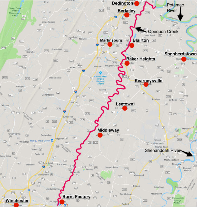
Many of the following records referred to the Shenandoah River as Sherando. Also, you’ll find many of the descriptions as being to one side or another, of Opequon Creek. The Opequon (spelled a variety of ways in the records) is a 64.4-mile-long tributary stream of the Potomac River. It flows into the Potomac northeast of the current Martinsburg, Berkeley County, West Virginia. Its source lies northwest of the community of Opequon at the foot of Great North Mountain in Frederick County, Virginia. The cities and towns along the Opequon Creek include current day Beidngnton, West Virginia; Berkeley, West Virginia; Blairton, West Virginia; Martinsburg, West Virginia; Baker Heights, West Virginia; Kearneysville, West Virginia; Leetown, West Virginia; Middleway, West Virginia; Burnt Factory, Virginia; and Winchester, Virginia. See map below.
Minor Grants noted by Cartmell
The following are some of the Minor Grants noted by Thomas Kemp Cartmell:10
- Stephen Hansonbella (Hotsinpeller) – 450 acres near head of Opecquon Creek
- Christian Nisswanger – 435 acres
- Thomas Wilson – 165 acres on Operkon Run
- John Van Meter – 475 acres, being the lowermost part of that tract whereon John Lilburn resided on Operkon Creek, part of the Van Meter Grant;
- Thomas Chester – 100 acres on North side of North River;
- Louis Stuffey – 339 acres on West side of Sherando River near head of Crooked Run
- Robt. Desarfe – 300 acres near place called Long Meadows adjoin Isaac Hite, son of Joisst Hite
- Christian Blank – 60 acres on North side of North branch of Sherando River “being within the bounds of ten thousand acres granted to John Van metre on June 6th, 1730, and sold to Hite, Oct. 1734;”
- Hendery Hunt – 120 acres on West side of Sherando River “being part of the 40,000 acre grant purchased by Hite from John Van Meter.
All of the following deeds were recorded in the Orange County Court prior to the holding of the first term of court in Frederick County, and are from Joist Hite:
- John Seaman – 26 October 1737 – 1,000 acres adjoining Benj. Borden.
- James Wood – 25 April 1738 – 100 acres on West side of “Opequon run.”
- William Williams – 27 April 1738, 225 acres on “Opequon run.”
- Louis Stevens – 28 April 1738 – 339 acres—Crooked run.
- Peter Writtenhouse – 21 May 1740 – for 450 acres adjoining Long Meadow.
- Jacob Christman – 14 May 1740 – 750 acres.
- John Hite – 21 May 1740 – 568 acres, part of Hite’s grant and also 100 acres adjoining, purchased by Joist from Richard Pendall on “Opequon”.
- William Reed – 14 May 1740 – 210 acres on the southwest side of “Opequon run.” part of Hite’s
grant—1734. - John McCormick – 26 May 1740, 395 acres adjoining the Borden, Griffith and Hampton, etc. tract of 1122 acres. This grant was for land north of the point where White Hall village stands. [in 1909]
- Samuel Walker – 21 May 1740 – 100 acres on “west side of Sherando river”.
- Chas. McDowel – 20 Jul 1740 – 600 acres.
- James Burns – 24 May 1741 – 128 acres on “west side of Sherando”.
- Robert Allen – 21 May 1742 – 685 acres on “south side of Opequon run”. This tract was west from the Bartonsville section.
- John Harrow – 19 May 1742 – 290 acres on “north side of Opequon run.”
- Abram Wiseman – 23 June 1734 – 172 acres on “west side of Opequon run”—part of the 5,018
acres Hite Grant. - James Vance – 23 June 1742 – 250 acres “on both sides of small meadow near Opequon Presbyterian meeting house”.
- Peter Make – 23 June 1742 – 168 acres on “Opequon run.”
- David Vance – 20 May 1742 – 100 acres on both sides of the “Opequon run.”
- James Hoge – 26 May 1742 – 760 acres. This was near the present [1909] site of Kernstown, lying West—and was part of Joist Hite’s grant for 3395 acres, known as the Springdale Settlement, where Col. John Hite lived.
- Jacob Hite – 20 October 1742 – 2668 acres on “south side of Opequon.”
- John Pentz – 20 Oct 1742 – 189 acres on “north side of Sherando river.”
- Thomas Brown – 20 Oct 1742 – 882 acres on west side of Sherando river.
- Samuel Glass – 26 Nov 1742 – 900 acres on the head of Opequon on west side of said creek,
meaning south at that point. - David Logan – 26 Nov 1742 – 860 acres on “west side of Bufflow Meadow”—known for years as Buffalo Marsh.
- Paul Froman – 22 Nov 1742 – 120 acres on North fork of Sherando river, adjoining Thomas
Chester. - Emanuel Grubb – 26 August 1742 – 250 acres on north side of Shenandoah river.
- John Grubb – 26 Aug 1743 – recorded same day, 265 acres on “north side of S. River.”
Land Grant Disputes
As noted, there were several land grant disputes regarding the “Virginia’s Northern Neck” area, including the following:
Hite / Virginia Council
From Thomas Kemp Cartmell’s Shenandoah Valley Pioneers and Their Descendants:11
A brief mention of the conveyances by Hite at that period, is given here for two reasons: it settles one point, that Hite actually purchased the Van Meter grant which ante-dated his by four years[?], and that he also found it necessary to use the same to give title to his fellow-colonists. As has been stated elsewhere, the specific terms of the original Hite grant required him to make a settlement in the new country of not less than twenty families; and having this accomplished, he must allow them to make selection for their habitations such parcels of land not theretofore granted to actual settlers, and then convey them, out of his grant, good title for their home.
When some of these selections were made and reported to the Council at Williamsburg for approval, Hite was informed that his grant could not embrace many of these tracts, —as they were either within the Van Meter grants already surveyed, or they were parts of tracts leased by agents of the Fairfax estate. These leases were to run twenty years in most cases; and just at that point began the question of who was owner. Some of the colonists preferred to take their chances with the Fairfax claim; and held on to their selection, and became what was known after as squatters; and they and their descendants were at law with Lord Fairfax after his arrival in 1749. Many of these suits were pending in our courts after Lord Fairfax’s death, many of them losing their homes.
Lord Fairfax / Virginia Council
As the Virginia government (Council) at Jamestown were losing control over a significant portion of Virginia held by Lord Fairfax, the feud between them was significant. As stated, the specific issue at this time was the southern and western boundaries of the proprietary.
In 1735 Lord Fairfax came to Virginia to see about a survey to settle the matter.The survey was undertaken in 1736 and the next year Fairfax returned to England to argue his case before the Privy council. Before leaving, he rode over much of his domain, and set aside for himself a tract of 12,588 acres near Great Falls, in what was to become Fairfax County. A second survey was conducted with great difficulty in 1746 setting a line (Fairfax Line) between the sources of the Potomac and Rappahannock. The Fairfax line was a surveyor’s line run to establish the limits of the “Northern Neck land grant” (also known as the “Fairfax Grant”).
In 1747, Lord Fairfax came back to Virginia, two years after having won his claim before the Privy Council to the most extensive boundaries for the proprietary in exchange for certain land concessions to the Virginia authorities.
Hite / Fairfax
The Hite v. Fairfax lawsuit was decided by the Supreme Court of Virginia that upheld the original title of land granted to Thomas Fairfax, 6th Lord Fairfax of Cameron over the Northern Neck of Virginia, between the headwaters of the Potomac and Rappahannock Rivers Claimed by Jost Hite. Future Chief Justice of the United States John Marshall successfully represented the successors of Fairfax to the title.
Joist Hite and Lord Fairfax were in a 53 year long legal battle, from 1749-1802. Part of the Hite vs Fairfax suit was fought by John Marshall, who eventually became Chief Justice of the U.S. Supreme Court. Marshall represented Fairfax.
Lord Fairfax considered the settlement of the Hite grants as a “conspicuous trespass upon his proprietary rights,” and the permissive policy of the colonial authorities provided him with grounds for accusing Jost Hite of “gerrymandering” his claim into a “shoestring,” frustrating future growth of the Valley settlements and making himself (Hite) and partners rich at the expense of others.
On the first judgement, in 1784, Fairfax won the suit, but Hite appealed. In 1786, judgement was returned in favor of the Hites. By the time the final settlement was achieved around 1802, all of the principals to the cause were deceased.
The Northern Neck Proprietary was not seized during the Revolutionary War as Lord Fairfax had been a resident in Virginia since 1735 and was not considered an alien. His office continued to operate until 1781, shortly after his death. The ownership was in dispute until the last surviving heir sold his title to the last manor in 1808, thus terminating the Fairfax family interest.
Van Metre "Sharp Practice" - Really?
The following was written by Cartmell12
It has been speculated that the Van Metre brothers sold to Hite and then bought back their portions in order to confuse the legal battle that was going to happen and the Van Metre’s well knew what Lord Fairfax and Governor and Council of Virginia did not know at that time, as to what was the extent of the Fairfax Grant; hence Van Metre resorted to what would be called to-day “sharp practice,” by transferring his entire grant into the possession of a third party, Jost Hite, and then to become holders of such portion as they desired for themselves by transfer and purchase from Hite. This became later, as Van Metre no doubt anticipated, a subject of litigation, –and it was not finally settled until after principals and their children had been dead many years. The courts sustained Van Metre, and confirmed title to all assigns for interest in the Van Metre grants purchased from “Jost Heitd,” the legal battles were fought to a finish in 1802.
I question the speculation that the Van Matre’s resorted to “sharp practice”. There is nothing (except conjecture) to substantiate this claim. According to Cartmell, Hite is the one who approached the Van Matre’s to obtain their grant. It is my opinion that the Van Matre’s had chosen the land they wanted, including land for family and friends. Turning the task of getting the additional families to meet the grant requirements may have been a relief. This would allow them to focus on developing their land and getting their families settled. Also, this was done in 1731. Fairfax didn’t have the land surveyed until 1736-37. There is no explanation of how the Van Metre’s would have known about the extent of Lord Fairfaxes proprietary before anyone else, even Lord Fairfax himself. Having said that, it is possible that they knew the “lay of the land” through John Van Metre’s travels. IF (a big IF) they had knowledge of the description of the Fairfax Proprietary, they may have been able to figure this out. In this case, however, why would they want to obtain property that could be in dispute? Could they have figured it out between the time of their grant in 1730 and the time they turned it over to Jost Hite in 1731? Yes. However, again, it appears that Hite is the one who instigated the change. I’ll leave this to the reader to make their own opinion.
Citations and Attributes:
- Survey of the Northern Neck of Virginia, 1736 & 1737. By John Warner (active 1727-1741) - This map is available from the United States Library of Congress's Geography & Map Division under the digital ID g3880.ct000362. This tag does not indicate the copyright status of the attached work. A normal copyright tag is still required. See Commons:Licensing for more infor- matio. Public Domain. https://commons.wikimedia.org/w/index.php?curid=31539987.
- Lord Thomas Fairfax, 6th Lord Fairfax - a black and white reproduction of an oil portrait painting of Thomas Fairfax 6th Lord Fairfax of Cameron. The original portrait is located at the Alexandria-Washington Lodge No. 22 A.F. & A.M. in Alexandria, Virginia. https://commons.wikimedia.org/wiki/File:ThomasFairfax6th.jpg#/media/File:ThomasFairfax6th.jpg
- Council of Colonial Virginia, Vol IV (October 25, 1721-October 28, 1739), published by The Virginia State Library, 1930, pages 223 & 224. Reviewed onliine at archive.org: https://archive.org/details/executivejournal04virg/page/n5/mode/2up (Accessed 4 apr 2023).
- Survey of the Northern Neck of Virginia, 1736 & 1737. By John Warner (active 1727-1741) - This map is available from the United States Library of Congress's Geography & Map Division under the digital ID g3880.ct000362. This tag does not indicate the copyright status of the attached work. A normal copyright tag is still required. See Commons:Licensing for more infor- matio. Public Domain. https://commons.wikimedia.org/w/index.php?curid=31539987.
- Samuel Gordon Smyth, A Genealogy of the Duke-Shepherd-Van Metre Family, 1909.
- Henry Z. Jones, Ralph Connor, Klaus Wust, German Origins of Jost Hite, Virginia Pioneer, 1685-1761; 1979.
- Lee Case website: http://leecase.tripod.com/hite.htm#. Last updated 10 November 2002. (Accessed 13 January 2018)
- "Isaac and John Vanmetre Land Grant assignees". USGenWeb Archives online. Submitted by Gwen Hurst. (http://files.usgwarchives.net/va/frederick/land/landgrants/v5360000.txt. (Accessed 29 August 2016).
- "Fairfax and Jost Hite Land Surveys, Shenandoah River, 1734-1735." Frederick Co., VA." US GenWeb Archives online. Submitted by Gwen Hurst. (http://files.usgwarchives.net/va/frederick/land/landgrants/h3000000.txt. (Accessed 29 August 2016).
- Cartmell, Thomas Kemp, Shenandoah Valley Pioneers and Their Descendants: A History of Frederick County, Virginia, 1909.
- Cartmell, Thomas Kemp, Shenandoah Valley Pioneers and Their Descendants: A History of Frederick County, Virginia, 1909.
- Cartmell, Thomas Kemp, Shenandoah Valley Pioneers and Their Descendants: A History of Frederick County, Virginia, 1909.