New Jersey History & the Migration of our Van Metre family
This post is about the early New Jersey History and the three counties our Van Meter / Van Meteren family records were found during the early generations: Somerset County, Burlington County and Salem County.
Somerset County
Jan Joosten and Joost Janse Van Meteren are showing up in Somerset County, New Jersey as early as 1689. Joost Janse and Sara DuBois’ son Isaac was born in West Jersey in 1692. Joost Janse and Sara’s son, Jan Joost (aka John Van Matre) and his wife Sarah Bodine, had a daughter, Sara, baptized in Somerset County, New Jersey in 1706, where Joost Janse shows as a witness.
In 1700 Jan Joosten appears in the Province of East Jersey as a purchaser of lands in Somerset County. The lands were designated as unappropriated and un-surveyed tracts, lying contiguous and located on the South Branch of the Raritan River, which was in the vicinity of the present town of Somerville.
Burlington County
Jan Joosten Van Meteren and Macyke Hendricks had returned to Marbeltown, New York by the time their son Henry was born in 1695, but we find land records again in 1695 in Lazy Point, Burlington County. In 1695, in partnership with his son-in-law, Jan Hamel, who had married Geertje Crom (Jan Joostens step daughter and Macykes daughter) in 1682.
Salem County
In 1714 Joost’s wife, Sara DuBois, her brother, Jacob and two sons, John and Isaac Van Matre later acquired a 3,000 acres of land in Salem County, between the Alloways Creek and Cohansey River, near Daretown. It appears this is where Sara DuBois settled after the death of her husband, Joost Janse. Her son, Henry would remain in this area and many of the Van Meters in this area are his descendants.
Table of Contents
Navigation by Water
So, we know our Van Meter families were fairly mobile during these years going back and forth between New Jersey to New York. It is well known that Jan Joosten Van Meteren was a Skipper and was the owner of at least one “yacht” and at one time was in the business of transporting people from Kingston to New York and Albany. Although he had probably retired from the business by the late 1600’s he most likely still owned his boat/yacht and that is how he transported the family. It is also likely he taught the trade to his older sons, John and Isaac.
It would be an easy trip from the Hudson River, or even the Wallkill down to the Raritan River to the current Summerville, New Jersey. From the Raritan, they could take the Delaware River down to Burlington and further south to Salem. Once in Salem County, the Alloways Creek is navigable from the Delaware River to Allowaystown, more than twenty miles from its mouth in the Delaware. Salem was an important shipping center in the early 1700s and water transport was common.
Of course they could have taken the Kings Highway, but my guess is via the waterways.
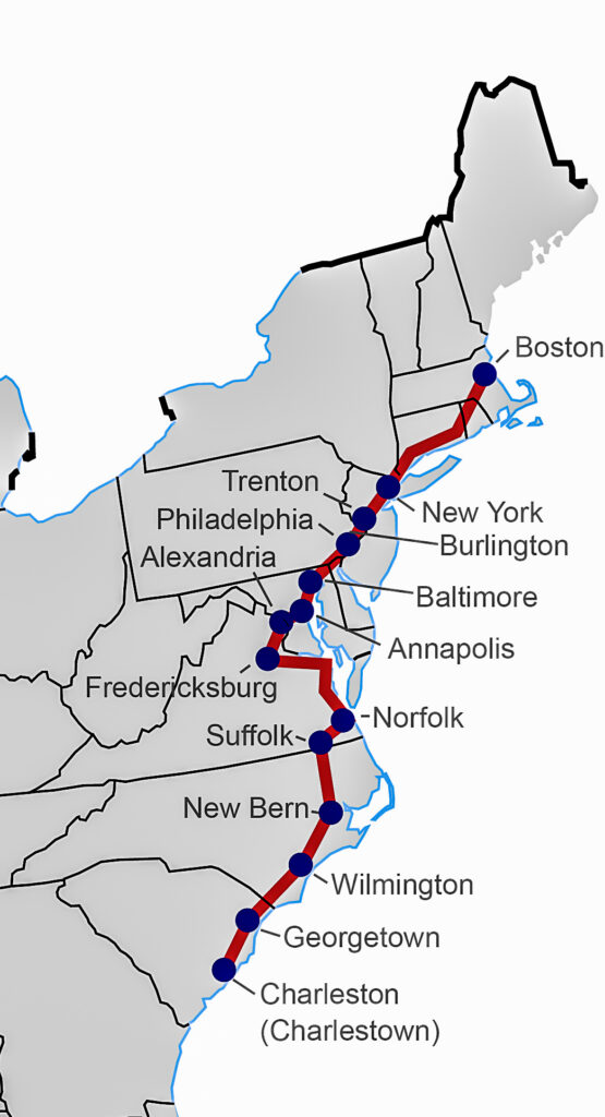
The Kings Highway
The path from New York to Philadelphia was called “The King’s Highway” in 1675, and was then the main artery of travel between the two chief cities of the eastern colonies.
Another path followed the eastern shore of the Delaware, intersecting the little Swedish villages that lay along the way between Somerset and Middlesex counties in the Province of East Jersey, on down to the vicinity of Fenwick’s English colony at Salem, in the province of West Jersey. En route, there was a divergence in the trail which led to Mattinicock Island and Lassa [Lazy] Point, situated about where the city of Burlington now stands [between Philadelphia and Trenton]. It was by these primitive paths that the various and widely separated settlements in the middle colonies were connected and from which they continually acquire growth from the flow of pioneers that were to pierce the Blue Ridge at the Potomac and absorb the virgin valleys beyond.1
New Jersey History
Between 1674 and 1702 New Jersey was comprised of the Province of East Jersey, and the Province of West Jersey. These were two distinct political divisions of the Province of New Jersey, which became the U.S. State of New Jersey. The following history is from the Red Book2, as follows:
After Henry Hudson’s initial explorations of the Hudson and Delaware River areas, numerous Dutch settlements were attempted in New Jersey, beginning as early as 1618. These settlements were soon abandoned because of altercations with the Lenni-Lenape (or Delaware), the original inhabitants. A more lasting settlement was made from 1638 to 1655 by the Swedes and Finns along the Delaware as part of New Sweden, and this continued to flourish although the Dutch eventually gained control over this area and made it part of New Netherland. By 1639, there were as many as six boweries, or small plantations, on the New Jersey side of the Hudson across from Manhattan. Two major confrontations with the native Indians in 1643 and 1655 destroyed all Dutch settlements in northern New Jersey, and not until 1660 was the first permanent settlement established—the village of Bergen, today part of Jersey City.
Of the settlers throughout the colonial period, only the English outnumbered the Dutch in New Jersey. When England acquired the New Netherland Colony from the Dutch in 1664, King Charles II gave his brother, the Duke of York (later King James II),all of New York and New Jersey.The Duke in turn granted New Jersey to two of his creditors, Lord John Berkeley and Sir George Carteret. The land was named Nova Caesaria for the Isle of Jersey, Carteret’s home. The year that England took control there was a large influx of English from New England and Long Island who, for want of more or better land, settled the East Jersey towns of Elizabethtown, Middletown, Piscataway, Shrewsbury, and Woodbridge. A year later, migrants from Connecticut founded Newark. In 1685, a large group of Scots came to Perth Amboy, but they were not part of the great wave of Ulster-Scots who in the 1720s began their immigration to the New World, including New Jersey. For a brief period, from 1673 to 1674, the Dutch regained control of New Jersey and New York, but it soon reverted back to the English.
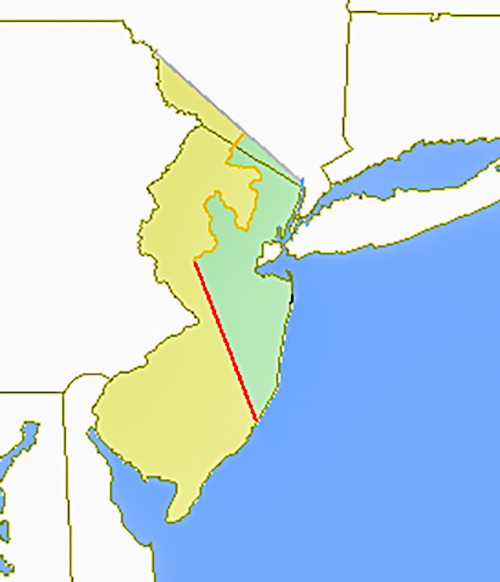
The King renewed his agreement with Carteret for control of the northern part of the colony, but not with Berkeley, who was forced to sell his interests in the southern part to Quaker John Fenwick. When Carteret died, his widow sold his interests to another group of Quakers, which included William Penn, who in 1676, forced the setting of a boundary that divided the colony into two provinces, East and West. These provinces were controlled by proprietors, with capitols at Perth Amboy and Burlington, respectively. The poorly surveyed boundary cut diagonally across the state in such a way that all of the southern part fell in West Jersey, and the northern in East Jersey.
Place Name Changes in New Jersey History
The following are the dates of the changes for the territory now known as New Jersey:
- 1660 – Bergen, New Netherlands was established
- 1664 – Bergen changed to a New Jersey Colony.
- 1665 – Bergen settlement and surrounding plantations and settlements were called Bergen County.
- 1676 until 1702 – Bergen was split into West Jersey and East Jersey and remained a settlement in East Jersey.
- 1681 – Courts were established for West Jersey in Burlington and Salem.
- 1683 – East Jersey’s counties, Bergen, Essex, Middlesex and Monmouth are formalized, each with its own court.
- 1688 – Somerset County was formed out of Middlesex County.
- 1694 – Burlington County was formed in the West Jersey Province.
- 1694 – Salem County was formed in the West Jersey Province.
- 1702 – East and West Jersey united as a royal colony called New Jersey.
- 1773 – Border was finalized (previously included part of the present state of New York).
- 1787 – New Jersey became the third state to ratify the U.S. Constitution and the first state to sign the Bill of Rights.
Somerset County, New Jersey
As one of America’s oldest counties, Somerset is steeped in colonial history. Somerset County, was settled in by the Dutch who purchased land from the English proprietors of the colony. It is named after the English county of Somerset. The county was established by charter on May 22, 1688, with land conveyances dating to 1651. Somerset County, is bordered to the northeast by the Passaic River and to the east by green. Brook and the Raritan River.
The inducements for relocating to New Jersey from Long Island and New York and seek a home in the wilderness was, first, to enjoy full religious liberty. Gov. Lovelace favored the Episcopal Church, and threw many obstacles in the way of those who belonged to the Dutch Church, of enjoying their own services in peace. Rather than yield one iota to his interference, they expatriated themselves a second time and came into the Province of New jersey, where the “Concessions and Agreements” secured ample religious freedom from the very beginning. Another second motive was no doubt found in the rich and unoccupied lands along the beautiful river, (Raritan) which seemed to invite the immigrant and promise him a reward for his labor in their culture and improvement.
Jan Joosten Van Meteren and Macyke Hendricks son Isaac, was born in the county on August 9, 1692. So assume Jan Joost had “spied out” the area prior to that date.5 On September 13, 1700, Jan Joosten Van Meteren acquired four parcels of land totaling 1,835 acres on the Raritan, River close to what is now Summerville, New Jersey.
The Dutch established the Reformed Dutch Church, with the first service being conducted by the Reverend Guiliam Bertholdf on March 8, 1699. After worshiping in homes and barns, a church building was built by 1709.
The Reformed Dutch church would evolve into the First Reformed Church, then a Second Reformed Church was established and a Third Reformed Church was established. These would eventually be combined into the current United Reformed Church in Somerville, which stands today, showing founded in 1699.
The earliest reliable record seen of the Raritan river, is found among the Albany records, and is date d1663, when the trade in furs with the Indians. There is said to be in the same records a tater from Herr van Werkhoven to Baren Vander Capellan, stating that the lands about Nevesink and the Raritan’s Kill, had been purchased for him in 1649, and complaining that they had not been allotted to him. This only shows that the value of these lands was already known as early as 30 years after the first settlements were formed around the “Trading Post” on Manhattan Island. It is said that in 1671 “both sides of the Raritan are adorned with spacious meadows, enough to feed thousands of cattle. The wood land is very good for corn, and stored with wild beasts; as deer, elks, and an innumerable multitude of fowl, as in other parts of the county. This river is though very capable for erecting of several towns and villages on each side of it; no place in North America having better convenience for the maintaining of all sorts of cattle for winter and summer food.”6
Burlington County and Lazy Point, New Jersey
Burlington County is in South Jersey region of the state. It is located east of the Delaware River and borders Philadelphia. The county stretches across the state and its southeast corner reaches tidal estuaries leading to New Jersey’s Great Bay, which separates the county from the Atlantic Ocean.
Burlington County was the seat of government for the Province of West Jersey until its amalgamation with east Jersey in 1702, forming the Province of New Jersey. The county was much larger and was partitioned to form additional counties as the population increased. In 1714 on partition to the north became Hunterdon County, which itself was later partitioned to form three additional counties (Morris, Sussex and Warren). The county seat had been Burlington but, as the population increased in the interior, away from the Delaware River, a more central location was needed and the seat of government was moved to Mount Holly in 1793.
In 1695, in parttnership with his son-in-law, Jan Hamel, who had married Geertje Crom (aka Gertrude and Girty Jans) in 1682, Jan Joosten van Meteren appeared in West Jersey, where they jointly bought on October 18, 1695, from Edward Hunloke, the deputy Governor, of Wingerworth, Burlington County, who was Deputy Governor under dr. Daniel Coxe, a plantation of 500 acres located at Lassa, or “Lazy” Point on the Delaware River, the present city of Burlington.” 7 Although Jan Joosten was owner of half the land, it’s not clear whether he lived there or not, as they are not present during some of the land transfers. I’m speculating that this land was purchased specifically for Jan Hamel and Geertie Crom, as in 1699 Jan Joosten deeded his half of the property over to Jan Hamel. This was about the time I believe him (Jan Joosten) to begin transferring his property directly to his heirs.
Lassa Point, about twenty-three miles northeast of Philadelphia, and was originally seated by three or four Dutch families “who were there”– said Governor Phlip Carteret–:in 1666″, and to whom he confirmed patents in 1678. The Mattinicock Island (now Burlington Island), which lay in the river opposite Burlington and Lassa Point, was subsequently the home of Peter Jeque, a noted Colonial character and trader. The property was on the path frequented by the Dutch traders in passing between the settlements on the Delaware and the lower Hudson, as is now marked by the site of the city of Burlington, New Jersey.8

Map of the Vicinity of Burlington, Province of New Jersey in the year 1679, showing location of Lazy Point.9
Salem County, New Jersey
In 1665, Salem was founded by Quaker John Fenwick. This is a short excerpt from the website “Descendants of Founders of New Jersey”.10
Salem was founded by Quaker John Fenwick in October 1665; the first English settlement established in West Jersey following the English defeat of the Dutch in 1664 and the first Quaker colony in North America, predating Philadelphia by seven years. Sweden made a royal claim on the region in the 1640’s; but yielded to the Dutch in 1654. However, in 1665 Fenwick’s new acquisition was mainly a vast wilderness of forest, bogs, meadows and waterways.
John Fenwick was born at Stanton Manor, England, in 1618, the second son of wealthy and prominent William Fenwick. John was appointed as a captain of Cavalry by Oliver Cromwell and took an active part in the fight against the Crown. About 1648, he married Elizabeth Covert, with whom he had three daughters. Abandoning the Church of England in 1665, he and his wife became members of the Society of Friends.
Fenwick was involved in a financial dispute concerning an undivided portion of New Jersey, which Lord Berkeley had sold to Edward Billinge for £1000, in 1675. The final outcome of the dispute was that for financial considerations Fenwick was granted a tenth of West Jersey. Known as the Salem Tenth, it encompassed 350 square miles in the Southwestern part of the state (much of what are Salem and Cumberland Counties today).
The majestic Salem Oak, which still stands today, is said to be the site where John Fenwick, entered into a treaty with the Lenni-Lenape tribe for the land that is Salem County today. The county derives its name from the Hebrew word for “peace”.
Salem County is the westernmost county in the state. Its western boundary is formed by the Delaware River and its eastern terminus is the Delaware Memorial Bridge, which connects the county with New Castle, Delaware. Its county seat is Salem.
European settlement began with the colonists in the seventeenth century who were settling both sides of the Delaware River. They established a colonial court in the area in 1681, but Salem County was first formally organized within West Jersey on May 17, 1694, from the Salem Tenth. Pittsgrove Township was transferred to Cumberland County in April 1867, but was restored to Salem County in February 1868.
The following is an excerpt from The History of Salem County, New Jersey: being the story of John Fenwick’s colony, the oldest English-speaking settlement on the Delaware River, written by Joseph S. Sickler, 1937:11
1665–The Founding of Salem–The Fenwick Colony
As in New Netherlands, it is quite to the honor of the Swedes, the Dutch and the English that, as far as this colony was concerned, the Indians were fully paid for their lands. Again, the Indian probably had no conception of the permanent possession of the land implied in the white man’s deed but supposed he was selling the right to hunt, fish and camp in accordance with his own customs. But at any rate, there are many certificates, signed with the marks of Indian chiefs acknowledging full payment for their lands. In exchange for their lands the Indians received hard liquor, combs, scissors, pipes and knives, shoes, looking glasses, beads, balls, etc. They also, in some cases, received a few guns, coats, a few handfuls of gunpowder and some bars of lead.
Despite this, within twenty-five years after the English occupation the red man was well elbowed out of Salem county. Dating this from Fenwick’s occupation in 1675, by 1710 at the latest, except for a few Indian servants in the homes of the early colonists, the great bulk of the red men had started on their northern and western trek.
Two Salem County townships, Alloway and Mannington, are named after the chiefs who occupied those localities when the white man arrived, Chiefs Alloway and Manito. Alloways or Aloes seems to have been kindly disposed towards the colonists and is said to have furnished grain and supplies to the famine-stricken settlers in one of the first winters. Both Alloway and Mannington creeks, considerable water courses in the county, have the same derivatives, while Nicomus Creek near Woodstown, crossed by state highway route 45, is named after another chief, one who signed the second purchase deed to Fenwick.
Salem was an important Shipping Center in the early 1700’s. It was to a large extent the actual making of the community. The pages of the early newspapers are full of items concerning the ships which entered and left Salem on their errands of commerce. Many fortunes which enabled their owners to build stately, colonial homes in this section, were because of the shipping industry. The use of Salem’s port kept up until the Revolution. A shipyard at Alloways was building ships for this same coast-wise trade.
The Old Salem County Courthouse, situated on the same block as the Salem County Courthouse, serves as the court for Salem City. It is the oldest active courthouse in New Jersey and is the second oldest courthouse in continuous use in the United States, the oldest being King William County courthouse in Virginia. The courthouse was built in 1735 during the reign of King George II using locally manufactured bricks.
Upper Pittsgrove – The Van Meters Land Acquisitions12
Sara DuBois with her sons John, Isaac and Henry, her brother Jacob DuBois, from Esopus [News Paltz], and his sons Barent, Louis and Gerritt, came to and established a domicile in Salem County, under a Grant dated “19th day of June, 1714, Colonel Daniel Coxe, agent for the West Jersey Proprietors, and at Burlington, the seat of provincial government of West Jersey–by an indenture of lease and release, granted unto Jacob Dubois, and his sister, Sara Dubois, alias Van Meteren, 3,000 acres of land in the vicinity of Salem.”
On the first of September, 1716, by a family arrangement, the 3,000 acres surveyed by Benjamin Acton, were so divided that each of the parties received about four hundred and fifty acres, and in the course of a few years these allotments were augmented by individual purchases of other lands from different settlers, as we find by various and sundry records of the county court. The DuBois brothers took the north half and the van Meter brothers took the south half. The 3,000 acres were located between the Alloways Creek and the Cohansey River in Upper Pittsgrove near what is now Daretown.
John Van Meter added to his dividend 600 acres, purchased in 1716 from John Powell–land that was formerly owned by Edward Champlneys, son-in-law and an heir of John Fenwick, the original proprietor. Isaac Van Meter, in addition to his dividend, secured in 1720, by purchase from John Dickinson, Jr., son of John Dickinson, the elder, 500 acres of land, it being a portion of the property formerly of John Champneys, grandson and an heir of Major John Fenwick. In 1721 he acquired from William Trent, of Trent Town, a tract of 320 acres called “Pilesgrove Manor Plantation,” originally owned by Thomas Hall, and which, upon his death, had come into the possession of his widow, the famous Sarah Hall.
There is no evidence that Jacob DuBois relocated to the area, but that his sons settled in the area.
The following is an excerpt from a good write up I found online of a brief history of Upper Pittsgrove:[/efn_note] 13
A Brief History of Upper Pittsgrove
For over 300 years, Upper Pittsgrove Township has been a land of farm fields and family homesteads, with a rich heritage of colonial settlers, Revolutionary patriots, enduring churches, educational opportunities, and agricultural production. As part of Quaker Englishman John Fenwick’s original colony in 1675, this region was once included in Pilesgrove Township, which at that time encompassed the entire eastern portion of Salem County. Pilesgrove was named after Thomas Pile, one of the early Quaker settlers, and it originally included all of present day Pilesgrove Township, Woodstown, Upper Pittsgrove Township, Elmer, and Pittsgrove Township.
This region was first settled in the 1690s and early 1700s by a handful of English, Dutch, and French Huguenot settlers, many of whose descendants still live on the same land today. Some of the earliest English settlers in the Pole Tavern area were the Elwells, the Paullins, and the Mayhews, who later helped form the Pittsgrove Baptist Church. A few Quaker families in the region included the Davises, Dickinsons, and Champneys, although many of these families later associated with the Baptist Church as well. In the 1710s, a number of French Huguenot and Dutch Reformed families from the Dutch colony at New Paltz, New York, bought land in the Daretown area; this settlement was started by the DuBois, Newkirk, and Van Meter families. The Nelson family, who also came here in the 1710s, were descended from the New Sweden colonists who had been in the Delaware Valley since the 1650s. These were some of the original settlers who formed the beginnings of Upper Pittsgrove Township.
In the Daretown region, Cornelius Nieukirk was the “first and chief promoter of the gospel in this place,” as these families sought a Presbyterian pastor to minister amongst them during the early 1700s. In 1740, evangelist George Whitefield preached here to about 2,000 people. Soon afterwards, the Pittsgrove Presbyterian Church was incorporated in 1741. The old brick church built in 1767 is still standing in Daretown. This was also the site of the Log College, a school to prepare young men for the ministry, the law, or other higher education. Adjacent to the church is the old cemetery where many of these original families were laid to rest.
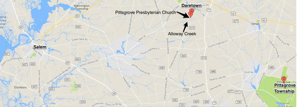
The Old Pittsgrove Presbyterian Church
Although the descendants I will follow, migrated to Virginia by about 1740, their brother Henry stayed in New Jersey and most of the Van Meters in the area are descended from him. However, brother Isaac stayed in the area long enough to assist with establishing the Old Pittsgrove Presbyterian Church, before moving on to Fort Pleasant, Virginia (now West Virginia) as was noted in the A Genealogy of the Duke-Shepherd-Van Metre Family:14
Many of the families during the first half of the 1700’s had baptized their children in the First Presbyterian Church at Philadelphia. It is recorded that the Van Metre family and friends were anxious to have a place of worship established among them and they made persevering efforts to obtain it. “On the 22nd of May, 1739, Isaac Van Metre, “on behalf of himself and many inhabitants of Pilesgrove,” made application to the Philadelphia Presbytery to the effect, but the project met with considerable opposition from the congregation at Deerfield, in Cumberland County, a few miles away. The matter dragged along for the two succeeding years, the people meanwhile worshiping in a school house and at private residences; the movement, however, being finally successful, a covenant was signed organizing the Presbyterian Church of Pittsgrove [Pile’s Grove], and among the first to sign the covenant were: Issac Van Metre, Hanna, his wife, their son Henry and daughter Sarah; and among the thirty or more signatures following appear the names of Cornelius Newkirk, his wife Rachael and their son Abraham; Barent du Bois and his wife Jacomyntje. The first marriage there was that of Isaac’s daughter Sarah to John Richman, 27th January, 1741/2. Under the influences of this church Isaac’s children were reared and a number of them have been among its leading officers; Isaac was one of the first elders.”
On April 30, 1741, The Presbyterian Church (now referred to as the Old Pittsgrove Presbyterian Church) was organized.
The Revolutionary War
On August 16, 1775 it was decided that the militia forces of this county should consist of one regiment including three companies of minute men. The muster roll of this first company formed within the confines of Salem county included these men:15
Jacob Dubois, Captain; Peter Dubois, First Lieutenant; Abram Dubois; Second Lieutenant… and among the Privates were: Jacob Vanmeter, Isaac Dubois, Isaac Vanmeter, Samuel Dubois, John Dubois and Benjamin Dubois.
AD
Citations and Attributes:
- Samuel Gordon Smyth, The Origin and Descent of an American Van Metre Family, 20 Oct 1923.
- Red Book, Third Edition, edited by Alice Eichholtz, Ph.D., C.G. 1989, 1992, 2004, p.446.
- A map of the King's Highway showing modern state borders. By TastyCakes - Own work, Public Domain, https://commons.wikimedia.org/w/index.php?curid=7679013 (Accessed 7 Mar 2023).
- The Provinces of East Jersey and West Jersey. The Keith Line of 1687 is shown in red. The Coxe and Barclay line of 1688 is shown in orange.By Matthew Trump, CC BY-SA 3.0, https:// commons.wikimedia.org/w/index.php?curid=2633713 (Accessed 7 Mar 2023).
- "New Jersey Births and Christenings, 1660-1980", database, FamilySearch (https://familysearch.org/ark:/61903/1:1:FC5T-NT1 : 14 February 2020), Isaac Van Meter, 1692.
- Messler, Abraham, D.D., "New Jersey Genealogy Trails website "Somerset County, NJ, centennial History of Somerset County, NJ", New Jersey Genealogy Trails, Somerset County, NJ, Centennial History of Somerset County, NJ, NJ, C.M. Jameson, Publishers, 1878, Transcribed by veneta McKinney, reviewed online at http://genealogytrails.com/njer/somerset/history.html (Accessed 19 Mar 2023).
- Documents Relating to the Colonial, Revolutionary and Post-Revolutionary History of the State of New Jersey. New Jersey Colonial Documents, Vol 21, p 464.
- Samuel Gordon Smyth, The Origin and Descent of an American Van Metre Family, 20 Oct 1923.
- Map of the Vicinity of Burlington, Province of New Jersey in the year 1679, showing location of Lazy Point.Burlington, New Jersey. 1679 By Sarnold17 (talk) (Uploads) - Own work, CC BY-SA 3.0, https://en.wikipedia.org/w/index.php?curid=29339221
- Descendants of Founders of New Jersey website, 1665-The Founding of Salem-The Fenwick Colony, http://www.njfounders.org/history/1665-founding-salem-fenwick-colony (Accessed 20 Mar 2023).
- Joseph S Sickler, The History of Salem County New Jersey, 1937.
- Almanac and Year Book, First National Bank
Woodstown, N.J. Reprinted 1974 John Fenwick Colony Tercentenary Committee, Reviewed online at ancestry.com: https://www.ancestry.com/imageviewer/collections/11080/images/dvm_LocHist002099-00001-1?, page 93 (Accessed 20 Mar 2023). - A Brief History of Upper Pittgrove, posted online at https://upperpittsgrovehistory.wordpress.com/a-brief-history-of-upper-pittsgrove/ (Accessed 19 Mar 2023).
- Smyth, Samuel Gordon. "A Genealogy of the Duke-Shepherd-Van Metre Family." Lancaster, Pa. 1909. pages 18-19, https://archive.org/stream/genealogyofdukes02smyt#page/n5/mode/2up (Accessed 20 Mar 2023).
- Sickler, Joseph S., "The History of Salem County New Jersey", 1937, p.138.