History of Iowa

Iowa Territory
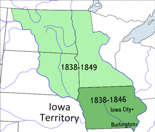
The Territory of Iowa was an organized incorporated territory of the United States that existed from July 4, 1838, until December 28, 1846, when the southeastern portion of the territory was admitted to the Union as the state of Iowa. The remainder of the territory would have no organized territorial government until the Minnesota Territory was organized on March 3, 1849.
Most of the area in the territory was originally part of the Louisiana Purchase and was a part of the Missouri Territory. When Missouri became a state in 1821, this area (along with the Dakotas) effectively became unorganized territory.

The area was closed to white settlers until the 1830s, after the Black Hawk war ended. It was attached to the Michigan Territory on June 28, 1834. At an extra session of the Sixth Legislative Assembly of Michigan held in September, 1834, the Iowa District was divided into two counties by running a line due west from the lower end of Rock Island in the Mississippi River. The territory north of this line (which started just south of the present-day Davenport) was named Dubuque County, and all south of it was Demoine County. When Michigan became a state in 1836 the area became the Iowa District of western Wisconsin Territory – the region west of the Mississippi River.
The original boundaries of the territory, as established in 1838, included Minnesota and parts of the Dakotas, covering about 194,000 Square miles of land.
Burlington was the stop-gap capital; Iowa City was designated as the official territorial capital in 1841.
Iowa Native Americans
American Indians of Iowa include Ho-Chunk (Winnebago; often classified as Hochunk-Slouan Speakers), Ioway (Baxoje), Missouria and Otoes.
The Chiwere-speaking tribes are descended from the prehistoric Oneota culture. At the time of contact with European explorers, their range covered most of Iowa. The Ho-Chunk ranged primarily east of the Mississippi in southern Wisconsin, the Ioway/Baxoje ranged in northern Iowa, the Otoe in central and southern Iowa, and the Missouria in far southern Iowa. All these tribes were also active during the historic period.
The force relocation of tribes in the 19th century from east of the Mississippi led to some eastern tribes living in and near Iowa. Their former territory had been around the Great Lakes. Potawatomi Chief Sauganash founded the village that eventually grew into Council Bluffs.
Winnebago Removal to Iowa
Historical evidence reveals the fact that at one time the northern part of Winneshiek county formed a small part of the vast hunting grounds of the Sioux Indians, and that the southern portion was given over to the Sauk and Foxe. In a council held at Prairie du Chien [Wisconsin], August 19, 1825, a boundary line was established between the Sioux, on the north, and the Sauk and Foxe, on the south. The principal object of this treaty was to make peace between these contending tribes as to the limits of their respective hunting grounds in Iowa.
This boundary line began at the month of the Upper Iowa river and followed the stream, which traverses Winneshiek county, to its source. In order to decrease still further the encounters between the Sauks and Foxes, on the one hand, and the Sioux, on the other, the United States secured, at a council held at Prairie du Chien [Wisconsin] July 15, 1830, a strip of territory twenty miles wide on each side of the boundary line already established and extending from the Mississippi to the east fork of the Des Moines. This strip, forty miles in width, was termed the “Neutral Ground.” The tribes on either side were to hunt and fish on it unmolested, a privilege they ceased to enjoy when this territory was ceded to the Winnebagoes. In this way the tract of land now known as Winneshiek county became a part of the Neutral Ground.
September 15, 1832, the Winnebagoes ceded to the United States their lands south of the Wisconsin and Fox rivers, east of the Mississippi. The government on its part, by this treaty granted to the Winnebagoes “to be held as other Indian lands are held, that part of the tract of country on the west side of the Mississippi river known as the Neutral Ground, embraced within the following limits.” The boundaries specified confined the Winnebagoes to that portion of the Neutral Ground extending forty miles west of the Mississippi. By the terms of this treaty they were to be paid $10,000 annually for twenty-seven years, beginning in September 1833.
November 1, 1837, a treaty was concluded with the Winnebagoes at Washington, by the provisions of which they ceded to the United States the remainder of their lands on the east side and certain interests on the west side of the Mississippi river, and agreed to remove to a portion of the Neutral Ground in Northeastern Iowa, set aside for them in the previous treaty of September 15, 1832. This treaty of 1837 was loudly proclaimed by the tribe to be a fraud. It was stated that the delegation which visited Washington in that year had no authority to execute such an instrument. Chiefs, also, who were of this party all made the same declaration.
The first attempt to remove the Winnebagoes was made in 1840, when a considerable number were induced to move to the Turkey river. That year a portion of the Fifth and Eighth regiments of U. S. infantry came to Portage, Wis., to conduct their removal. Antoine Grignon and others were connected with this force as interpreters.
Two large boats were provided to transport the Indians down the Wisconsin river to Prairie du Chien. Captain Sumner, who later was a commanding officer at Fort Atkinson, secured 250 Winnebagoes in southern Wisconsin. These were also taken to Prairie du Chien. They first disliked the idea of going on to the Neutral Ground, because on the south were the Sauk and Foxe, and on the north were the Sioux, and with these tribes they were not on friendly terms.
Considerable resentment was felt by the Sauk and Foxe towards the Winnebagoes for having delivered Black Hawk over to the whites, although previous to this occasion the Winnebagoes had been in intimate relationship with these tribes. However, they soon grew to love the Iowa reservation. 1
Winnebago Mission School and Trading Post
By the treaty of September 15, 1832, it was stipulated that the government should annually, beginning in September, 1833, and continuing for twenty-seven years, give the Winnebagoes $10,000 in specie, and establish a school among them, at or near Prairie du Chien, with a farm and garden, and provide other facilities, not to exceed in cost $3,000 a year, for the education of their children, and continue the same for twenty-seven successive years. Six agriculturists, twelve yoke of oxen and as many plows, and other farming tools were to be supplied by the government. The buildings were erected in 1833, on the Yellow river, Allamakee county, Iowa, and President Jackson appointed Rev. David Lowry, a Presbyterian minister, to assume charge. The mission school was removed in 1840, from the Yellow river to a point on the Turkey river, in Winneshiek county, about four miles southeast of the fort buildings.
The erection of the mission was superintended by Rev. Lowry. There were about twenty buildings at the mission. One was a large school house, another a small church, while the rest were dwellings. Early Catholic pioneers, who settled near the Turkey river (1849), purchased these buildings. The small church was used as a chapel, hence the name Old Mission. In 1853 it was destroyed by fire.
There was also a mission one mile east of the fort, on the Turkey river, established by Catholic missionaries. Here there were a number of graves, and at the head of each was a cross. It is unknown whether any of the graves were those of converted Indians or not. The buildings belonging to this mission were burned down by a prairie fire in the early fifties.
Alexander states that, “Rev. Lowry’s assistant was one by the name of Col. Thomas. To him was turned over the work of instructing the Indians in agricultural pursuits. The first year, under Col. Thomas’ supervision, a farm of 300 acres was opened. However, little work could be got out of them, and the crops planted began to show neglect.” There was an abundance of game in the country round about, and therefore the temptation for the Indian to roam and hunt was very strong. As a result he became negligent about tilling the soil. In 1843 Col. Thomas, under governmental instructions, built the first grist mill in Winneshiek county. The mission and farm was continued until the reservation was sold to the government. Lowry finally resigned to take charge of a mission in Minnesota and, in 1846, Mr. Fletcher was appointed agent for the Winnebagoes by President Polk, and served in that capacity for eleven years. During that time he resided at Fort Atkinson, Iowa, Long Prairie, Minn., and Blue Earth, Minn. Under the careful management of Mr. Fletcher the Winnebagoes attained to considerable proficiency in agriculture, and otherwise improved their condition.
During his service as Indian agent Mr. Fletcher was accompanied by his wife, who engaged earnestly in the work of teaching the Indians. Their eldest son, Frank Fletcher, acquired such command of the language of the Indians that he became his father’s interpreter. General Fletcher, while serving as agent, contributed through the publications of Mr. Schoolcraft a vast amount of information concerning the religion, traditions, and customs of the Winnebagoes while at the Turkey river. In 1858 Mr. Fletcher returned to Iowa, where he died April 6, 1872, on his farm near Muscatine, sixty-six years old.
When the crop, planted under Col. Thomas’ supervision, began to show neglect, a force of garrison men were detailed to cultivate it, and were paid for their labor out of the Indian annuity. Hon. A. Jacobson states 2 : “Ole Halvorsen Valle, undoubtedly the first Norwegian to visit the county, was engaged in the service of the government as teamster, hauling provisions from Fort Crawford, Wis., to Fort Atkinson and the Old Mission; he was also employed in breaking up pieces of bottom land on the Upper Iowa river. One of the largest fields thus prepared for the Indians to plant their corn was situated just below the outlet of Trout Run.” Mr. Goddard says, “An Indian chief had a farm about one-half mile southwest of Spillville, and a, considerable part of the ground was broken up.”
An Indian trading post was established two miles southwest of the fort by a Mr. Olmstead and one Joseph Hewitt. It seems that they had a permit from the government to trade with the Indians. The buildings, all one story high, were constructed of logs. There were five in number, two large dwelling houses, one large store, one storage house, and a blacksmith shop. Capt. Joseph Hewitt’s principal occupation was hunting, trapping, and fishing. In 1851 he left the country and located at Clear Lake, Ia., where he experienced no little trouble with the Sioux Indians. In 1849 Josiah Goddard bought the old Indian trading post from Olmstead, and in 1850 moved his family on to the land. Three or four acres of this land had been broken up by the Indians. 2 3
Fort Atkinson
Fort Atkinson was built to protect the Ho-Chunk (Winnebago) during their removal from Wisconsin. The name honors Henry Atkinson, the commanding officer in charge of the effort. Construction began in May 1840 and was complete Festina, Winneshiek County, Iowa by the summer of 1842. The regular army turned the fort over to Iowa volunteers as the troops stationed there were needed for the Mexican-American War. After the Ho-Chunk were removed from Iowa the post was abandoned on February 14, 1849.
Pioneer settlers were then allowed to move into the region. Some former soldiers at Fort Atkinson also remained and developed farms in the area. Historical records indicate that Gottlieb (Gotleib) Krumm, Gottlob Krumm, Charles Kregg (Kreggand), and Francis Rogers and their families were the first settlers in the region around the former military post once it was abandoned.
About 20 years later, in 1869, a railroad entered the region and the town of Fort Atkinson then developed down the hill southeast of the original post grounds.
Indian Removal in Iowa
American Indian: The Iowa Experience
At the time of the Louisiana Purchase in 1803 the lands bordering the Mississippi River were used by a number of Native Americans tribes and fur traders. By this time the federal government’s policy for Native Americans removal and relocation had become a highly organized operation.
The government purchased land from the Native American tribes in return for promises of relocation, protection and payment of tribal debts. After the land was purchased from the Native Americans, it was surveyed and divided. Then the government sold the land.
By 1830 the government had relocated a number of tribes within the future Iowa boundaries. The Sioux were assigned to an area around the Upper Iowa River. The Sauk and Mesquakie were placed south of the Upper Iowa River. The Winnebago were squeezed into a 40-mile zone along the Upper Iowa River.
Land for the European Settlers
European settlers were interested in the lands west of the Mississippi and began to pressure the government to purchase the land for settlement. The removal of the Native American tribes from the Iowa territory was fast. The first purchase of land for sale to settlers was the result of the Black Hawk War, an incident that took place in Illinois and Wisconsin. Black Hawk, a Sauk warrior, resisted removal from his land along the eastern side of the Mississippi River.
The outcome was disastrous for the Native Americans. The government used the incident to obtain lands in Iowa. The peace treaty demanded that the Sauk and the Mesquakie give up land west of the Mississippi. Five years later another land purchase was made, and the Sauk and Mesquakie were moved farther west.
Cheap Land for the Government
In 1841 when the United States government again approached the Sauk and Mesquakie for more land, the tribes recognized the hopelessness of their situation. They tried to sell their land in small parcels, hoping to get more money. The government refused. In the end there was no sale and no money for the already indebted tribes.
Poverty and debt forced the two tribes to make another treaty in 1842. All their lands in central Iowa were ceded. The Native Americans agreed to leave the area within three years. Debts to the traders were paid and yearly payments promised. The whole arrangement cost the federal government 11 cents an acre. The treaty-making continued. By 1862 Native Americans tribes had given up all the land in what is now Iowa. 4
Iowa State History
Iowa became a state on December 28, 1846 (the 29th state), and the state continued to attract many settlers, both native and foreign-born. Only the extreme northwestern part of the state remained a frontier area. The state was named after the Iowa River which was named after the Iowa Indians who lived in the territory. The Iowa tribal name “Ayuxwa” was spelled by the French as “Ayoua” and by the English as “Ioway”.
“The most powerful “native” Nations in present-day Iowa were the Sauk and the Meskwaki. The related peoples were driven west by the Haudenosaunee and then the French coming to Iowa in the 1700s. The first Europeans to visit the area were French explorers Jacques Marquette and Louis Joliet in 1673. The U.S. obtained the land in 180 as part of the Louisiana Purchase.
For the next several decades Iowa would be known as the Iowa Indian Territory. Conflict between natives and settlers in Illinois culminated in the United States forcing the people of the Upper Mississippi onto the wet bank of the river (out of Illinois and into Iowa). This led to the Black Hawk War in 183, and again in 1837. The United States displaced every native nation by 1852. The native population in Iowa today descends from Meskwaki and Sauk who later bought back land from the state.
When Iowa became a state in 1846, its capital was Iowa City, the more centrally located Des Moines became the new capital in 1857. During this time, large numbers of European settlers immigrated to the Midwest where there was abundant farmland. The settlers were a major motivator for the development of the state railroads in the 1850s.” 5
Iowa: Home for Immigrants
As the cession of native American lands in Iowa continued, settlement by the United States pushed further westward. By 1838 there were 22,859 people in Iowa, and 42,112 by 1840. One interesting occasion illustrating the westward push occurred on April 30, 1843. Much of the land in central Iowa had been ceded from the native Americans to the United States pursuant to the “New Purchase” in 1842. As the date at which settlement would be allowed approached, settlers gathered at the border to these new lands. On April 30, 1843, a cannon sounded at midnight, after which the settlers pushed into the new lands and settled many areas by sunrise. Most of the settlers who came into these “New Purchase” lands were from Illinois, Ohio, Indiana, Kentucky, and Missouri, and to a lesser extent Wisconsin, Virginia, and Pennsylvania.
By 1850, there were 192,214 people living in Iowa. Nearly 90% of the population at this time was from America, with Ohio, Indiana, and Pennsylvania contributing the most settlers.
The Civil War
Iowans voted overwhelmingly for Abraham Lincoln and sent 75,000 troops to fight for the Union in the Civil War. There were no battles in the state, but Iowa sent large supplies of food to the armies and the eastern cities. More than 75,000 Iowa men served, many in combat units attached to the western armies. 13,001 died of wounds or (two-thirds) of disease. Eight thousand five hundred Iowa men were wounded. The draft was not used in Iowa during the Civil War because Iowa had twelve thousand more men than the quota.
Iowa State Counties
Iowa currently has 99 counties. A fun way to see the county changes for all the states can be found at the Map Geeks website: Iowa can be found at https://mapgeeks.org/iowa/. That Interactive Map of Iowa Counties show the historical boundaries, names, organization, and attachments of every county, extinct county and unsuccessful county proposal from the creation of Iowa in 1816-1872. The following map is a current map of the state of Iowa and Counties.

Iowa History Timeline
1682 – Rene-Robert Cavelier de La Salle (1643-1687) explored the region for France.
1756 – 1756-1763, The Seven Years War (French and Indian War) due to disputes over land is won by Great Britain. France gives England all French territory eat of the Mississippi River, except New Orleans. The Spanish give up east and west Florida to the English in return for Cuba.
1775 – 1775-1783, The American Revolution creates the United States of America. The Revolution was due to the British burden of taxes and total power to legislate any laws governing the American colonies.
1776 – July 4, 1776 – United States Declaration of Independence.
1778 – July 10, 1778 – France declares war against Britain and makes an alliance with the American revolutionary forces.
1783 – September 3, 1783 – The Treaty of Paris is signed by the victorious United States and the defeated Great Britain.
1788 – Julien Dubuque becomes the first white settler in Iowa.
1800‘s– Conflict erupts between settlers and Native Indians of Iowa. The Native Indians were forced farther and farther Wet.
1803 – Part of the Louisiana Purchase: In 1803, the United States bought the Louisiana Territory from France. The U.S. Secretary of State, James Madison paid 15 million dollars for the land.
1832 – The “Black Hawk War” and the Sauk tribe was forced to cede their land.
1846 – Statehood – The Date that Iowa was admitted to the Union – December 28, 1846. Iowa was the 29th State to be admitted to the Union. State Motto: “Our liberties we prize and our rights we will maintain.”
1861 – The American Civil War 1861-1865. In 1859 John Brown raided Harpers Ferry and set in motion events that led directly to the outbreak of the Civil War. Abraham Lincoln, a known opponent of slavery, ws elected president and in 1861 the South Secedes. The initial Secession of South Carolina was followed by the secession of Mississippi, Florida, Alabama, Georgia, Louisiana, Texas, Virginia, Arkansas, Tennessee, and North Carolina. These eleven states eventually formed the Confederate States of America. The bombardment of Fort Sumter was the opening engagement of the American Civil War.
1885 – The surrender of Robert E. Lee on April 9, 1865 signaled the end of the Confederacy.
1865 – December 6, 1865 – The Abolishment of Slavery. The thirteenth Amendment to the U.S. Constitution is ratified, thus officially abolishing slavery.
1898 – The Spanish American War 1898-1901. On December 10, 1898, the Treaty of Paris, the US annexes Puerto Rico, Guam and Philippines.
Attribute:
- Iowa State Capital. By Iqkotze – Own work, CC BY-SA 3.0, https://commons.wikimedia.org/w/index.php?curid=9967341
- Map of Iowa Territory. By The original uploader was Fay2 at English Wikipedia. Transferred from en.wikipedia to Commons., CC BY 2.5, https://commons.wikimedia.org/w/index.php?curid=4339788
- Iowa State Counties Map. Altered. (https://mapgeeks.org/wp-content/uploads/2018/01/Map-of-Iowa-state-designed-in-illustration-with-the-counties-and-the-county-seats.jpg, (Accessed 4 July 2019).
- “Winnebago Removal To Iowa” retrieved from Access Genealogy Website online at https://accessgenealogy.com/native/winnebago-removal-to-iowa.htm (Accessed 5 Aug 2019).
- “Winnebago Mission School and Trading Post” retrieved from Access Genealogy online at https://accessgenealogy.com/native/mission-school-and-trading-post.htm (Accessed 5 Aug 2019).
- “Indian History of Winneshiek County, compiled by Charles Philip Hexom, A.K. Bailey & Son, Incorporated, Decorah, Iowa 1913, retirieved at hotcakencyclopedia.com website at https://hotcakencyclopedia.com/ho.HexomIndianHistoryWinneshiekCounty.html (Accessed 6 Aug 2019).
- “Indian Remval in Iowa” retrieved from Iowa Pathways website at http://www.iptv.org/iowapathways/mypath/indian-removal-iowa (Accessed 31 Jul 2019).
- Iowa State History, Infoplease website online at https://www.infoplease.com/us/states/iowa, (Accessed 4 July 2019).