St. James, Wynot and Brookey Bottom, Nebraska
St. James, Nebraska History
Wynot, Nebraska History
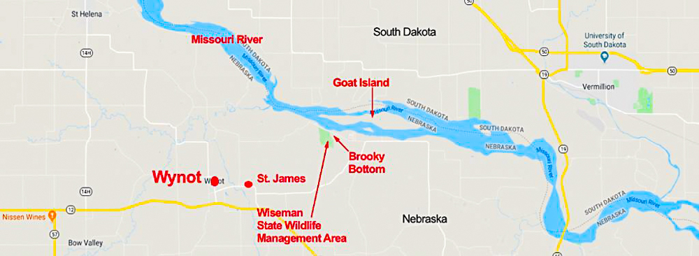
Where is Brookey Bottom?
Cedar County and Nebraska Timeline
St. James Timeline
Wynot Timeline
Update from Dennis Schulte
Update from Michael O’Connor
Several Ludwig Dörr descendants settled in Cedar County, Nebraska. This post covers the Wynot area (which includes St. James and Brookey Bottom). The descendants were mostly farmers, pioneers acquiring land around these communities, and would have been impacted by the events during this time. Note that Brookey Bottom is spelled Brooke in many records, but most stories show it spelled Brookey or Brooky.
In 1907 the railroad came through and chose to place their depot a mile west of St. James and establish a new town called Wynot and consequently most of the town of St. James moved to the new town.
Brookey Bottom, which is not on the map, is located a few miles northwest of St. James along the Missouri River off of Goat Island and a few miles northeast of the Old St. James. See update below from Dennis Schulte with more information on the location of Brookey Bottom.
St. James, Nebraska History
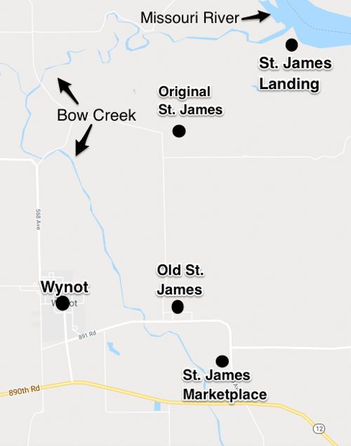
The town of St. James has had three separate locations:
- Originally St. James was located in 1857 about 1 1/2 miles north of the “Old St. James” location. The location on the map to the right is my best guess based on the descriptions given.1
– - St. James eventually transitioned starting in 1868 to its 2nd location, at the intersection of 569 Avenue and 891 Road in Cedar County and is referred to as Old St. James.
– - In 1907 after the railroad bypassed St. James, the community of Wynot, on the west side of the Bow Creek was established. Most of the inhabitants of St. James relocated to the new community called Wynot. The Catholic Church and school remained in what was to become the 3rd location of St. James. In 2000 the Catholic Church was closed and destroyed. Several local citizens (including our Pinkelman cousins) used the old school house to open the St. James Marketplace.
Townsley, a shareholder, sold part of his interest to Gates P. Thurston, who arrived from Dayton, Ohio in the spring of 1857 and is credited with laying out the original townsite with hopes of its eventually becoming Nebraska’s state capital. Thurston, who became Cedar County’s 1st Judge, built a 1-1/2 story log building, intended to be a courthouse, near this site. Though the original St. James was named Cedar County Seat when the county was organized by the Territorial Legislature on February 12, 1857, the courthouse was never used for its intended purpose. Instead it was used for religious services, meetings and as a fortress against Indian scares.
By 1860 St. James had a population of 50 which, according to that year’s federal census, included a merchant, carpenter, blacksmith, engineer, mechanic, minister, and lawyer as head of household. However, when a new flour mill was built in the mid-1860s about 1.5 miles upstream on Bow Creek, the original St. James Landing townsite moved to the mill’s location and what is now called Old St. James began to grow rapidly. Eventually Old St. James had the mill plus 2 hotels, a drug store, 2 merchandise stores, a saloon, 2 banks, a lumber store, 2 hardware stores, a blacksmith shop, 2 churches and a school.
Henson Wiseman, among the St. James area’s first permanent settlers, arrived there in 1857. Five Wiseman children were massacred by Native Americans near St. James July 24, 1863. Other 1857 area settlers were James Hay, O.D. Smith, Saby Strahm, John Andres, John McCoubray, a Mr. Wadsworth, and Henry, Ernest, Gustav and Herman Ferber, and their father, Paul Ferber. St. James Post Office, established July 13, 1858, was initially located in the pocket of whoever was postmaster at the time but soon was situated in Old St. James. It was discontinued May 31, 1909 when service began from nearby Wynot.
——-
I’ve listed the timeline of St. James below which shows the rich history of this pioneer community. In 1907 after two attempts to get the railroad to establish a depot in their town, they finally succeeded. However, the railroad company decided to make the depot a mile west of the town and across the Bow Creek instead of in St. James. A new town, called Wynot was established and most of the St. James community relocated to this new community. The Catholic Church and school was the exception.
Wynot, Nebraska History
The town came into being in 1907 as a direct result of railroad expansion across Cedar County. Efforts of citizens from St. James and neighboring farmers donated funds and land. They negotiated with the railroad in 1906 to have the line expanded to St. James. They were able to persuade the officials of the Chicago, St. Paul, Minneapolis & Omaha Railroad company to build its line to their town. But the railroad company ended up placing the depot on land a mile west of St. James because St. James didn’t have an adequate space for the depot and establishing it in St. James would have required them to cross Bow Creek twice.
In 1907 T. N. Jones and J. S. Emerson formed the St. Paul Townsite Company and purchased some land from a German settler named Willibold D. Schulte, across the creek and one mile west. Many businesses rushed to get in on the ground floor by working out of St. James until the rails were in place. There were later three additions to the original town site.
At a meeting of the townsite company the question of a name for the new town arose. Someone suggested a name which struck the fancy of the elderly Mr. Schulte who had sold the townsite land. He shouted ‘Ja, vy not? Wahrumnicht?” The brogue sounded strange to one of the listeners, who laughingly remarked “…why not, Wynot?” And so that name was chosen. [See update below for more details about Wynot and Mr. Schulte.]
The incorporation of Wynot was ordered on May 4, 1907 and the first train arrived in October 1907. In January 1908 a post office was established with J. S. Emerson as Postmaster. Mail service was started in April 1908. He served as postmaster until 1910.
The first child born in Wynot was the daughter of Mr. and Mrs. Arthur Wherry in October 1907. She was presented with a building lot by the town site company.
The first building completed in Wynot was the J. J.Cable Hotel. It is said that Mr. Cable traded a big team of horses for the lumberyard for materials.
- Methodist and Presbyterian Churches
- First National BankJ.S. Emerson and J.C. Zeigler general stores
- D. J. Sweet had the first lumberyard
- H.H. Mille and Company and Oscar Konegni hardware firms
- Charles Little cement block factory
- T. M. Jones flour and feed store
- Hoese and Schmidt general merchandise
- Doctor W.Y. Jones, Wynot’s first doctor
Other businesses that opened in Wynot when the town was first established
- Alex Schulte’s drug store move to Wynot from St. Helena where his father had a drug store
- R. W. Wright Jewelry store
- A second hotel was built in 1908 operated by John Nelson, carpenter
- H. A. McCormick started a newspaper “Wynot Tribune” first edition dated December 6, 1907
Where is Brookey Bottom?
Brooky Bottom Park, also called Brooky Bottom Recreation Area, has a boat dock, camping area, picnic spots and an open-sided shelter with a roof.
I found no evidence of a Brookey Bottom on any of the historical maps I found, but did find it on a Lower Missouri River Canoe Trail brochure3 by Nebraska Game Commission. It’s on Nebraska’s border with South Dakota along the Missouri River across from Goat Island, which is at the same location as noted. Use Highway 12, a scenic byway, to get there. Watch for the turn-off sign for Brooky Bottom, and take the gravel road to the park. Using GPS might not get you there.
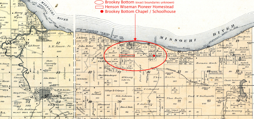
Based on family stories and biographies, at one time there was a little Chapel in a school house in Brookey Bottom [the map below shows the location of the schoolhouse in 1917 4 5]. This “Chapel” was where Joseph and Anna (Reifenrath) Imeohl were married. Annas birthplace is shown as Brookey Bottom. I combined the 1899 Plat Maps showing the location of St. James, Township 32N R2E and Township 32N R3E4 to show location of where I believe Brookey Bottom was located.
See update below provided by Dennis Schulte regarding the boundaries of Brookey Bottom.
Cedar County and Nebraska History Timelines
The following is just a short timeline of Nebraska and Cedar County.
Nebraska
1541 – Spanish explorer Francisco de Coronado is the first European to visit Nebraska.
1682 – Frenchman Robert Cavelier claims the land for France.
1803 – The United States buys Nebraska from France as part of the Louisiana Purchase.
1854 – The Kansas-Nebraska Act creates the Nebraska Territory and opens the territory to white settlers for the first time.
1854 – The city of Omaha is established
1862 – The Union Pacific Railroad is founded in Omaha.
1867 – Nebraska is admitted to the Union as the 37th state.
1877 – The Native American war leader Crazy Horse surrenders.
1939 – The Kingsley Dam is finished, creating Lake McConaughy.
Cedar County, Nebraska
1650 – Omaha Indians lived along the Bow Creek area. For the next 90 years the area that borders the Missouri River on the north was home to the Omaha, Ponca and Sioux tribes.
1804 – Lewis and Clark make the first treaty that was ever entered into the Federal government with the Sioux Indians at Brentz Hill, formally known as the Callumet Hill. (This place is located about four miles northwest of the town of St. Helena.)
1857 – Cedar County was organized by an act of the Territorial Legislature, named because of the number of cedar trees that were growing in the area.
1860 – The boundaries of the county were redefined in 1860 to their present dimensions.
St. James, Cedar County, Nebraska Timeline
1856 – The first St James settlement was plotted about a 1 1/2 miles northwest of the 2nd St. James location by Col. C. C. Van and Moses H. Deming.
1857 – On February 12, 1857 St. James was designated the first county seat for Cedar County, Nebraska.
Appoximately twenty families came from Harrison County,Iowa and Henson Wiseman and his family came from Sioux city, Iowa.
St. James is surveyed consisting of 640 acres.
In spring of 1857 Marshall Townsley built a log frame house also used as the first hotel in the area.
First Cedar County Court House built at St. James, a two-story frame building was constructed for $2,000.
1858 – Col. CC Van built the first saw mill in the county 1 mile east of St. James Erastus Meech opened a store in St. James.
St. James Post Office was established with Erastus Meech as the first postmaster on July 13, 1858.
1859 – First Blacksmith shop started in St. James.
Moses Deming opened a store in St. James and was appointed postmaster that year.
George A. Hall came to old St. James in the spring of 1859. He was elected county treasurer in the first election held in the county.
1861 – The county seat was moved from St. James to St. Helena.
First school was started in St. James and taught by Miss Bell Hay (Mrs. O.D. Smith).
1863 – Wiseman Massacre – Five children of Hessen & Phoebe Wiseman were massacred by Indians in July 1863.
1864 – In the spring of 1864, Lorenze Bentz was massacred near St. Helena.
“Great Stampede” St. James court house is used as a refuge against Indian attacks. The “Court House” building was used as a refuge against Indian attacks. The settlers at St. James fortified themselves in the court house by throwing up an embankment around the building and strengthening their positions. A well was even dug inside the stockade.
Late in 1864, Co. B 7th Iowa Cavalry was sent to protect the settlers against Indian attacks. A fortification was built which was called Fort Jackson. This fort was built on a high hill a short distance from the town which was known as the Harder place.
Flour mill started approximately 1 1/2 miles south of St. James by Henry Hoese. It was completed in 1868.
1867 – First Public School – St. James School – was built 2 miles North Northwest of Old St. James near Jones “Bow Valley” Mills.
1868 – Bow Valley Mill built. After being a partner with Hoese for 2 years, L.E. Jones left and started the Bow Valley Mill.
The Flour mill, built by Henry Hoese, was completed.
The town began gradually moving to the second St. James site (now referred to as Old St. James).
The Court House was sold to Henry Hoese, Sr., who moved it to the 2nd St. James location. It is told that it required thirty yoke of oxen to move it.
1869 – W. L. Dickenson family moved to St. James and ran the “Dickenson Hotel”
1870 – Gregor McGregor started a blacksmith shop. He made the St. James Canon.
1872 – Dr. H. E. McKenzie, pioneer physician arrived at St. James.
School built at St. James.
1874 – First fair in county was held in St. James.
St. James public cemetery laid out. Later known as the Bow Valley cemetery and then the Wynot Public cemetery.
St. James Public School was organized April 30, 1874. Public School merged with Sacred Heart District 101.
1875 – St. James canon used on July 4th.
First attempt to get rail service to St. James 1875-1876.
1881 – The “Great Flood” 200 people are sheltered at St. James.
1900 – By early 1900’s the businesses in St. James included the First National Bank, the farmers State Bank, J.S. Emerson Merchandise Store, H. H. Mills Hardware, D. F. Sweet Lumber Company, J.C. Zeigler Genral Merchandise Store, and another hardware store operated by Mr. Konegni.
1901 – Modern Woodman Picnic was held in St. James – 5,000 attended.
1904 – Sts. Philip and James Church built at St. James.
1906 – The second attempt to get rail service to St. James in a meeting held January 11th.
1907 – Railroad by-passes St. James and forms Wynot.
1907-1908 – Many St. James businesses went to the new railroad terminal, Wynot. The Catholic community stayed at St. James, since the Church, priest house and cemetery was already established.
1909 – May 31, 1909 the St. James Post Office was discontinued.
The Old Court House building burned October 1, 1909.
1919 – The St. Phillip and James School was completed in January 1919.
1935 – A Service Station for gas and oil was built.
1935 – The St. Phillip and James School was closed due to the inability to support it during the depression.
1939 – The St. Phillip and James School was re-opened under the Benedictine Order of Nuns from Yankton, S.D.
1952 – In January 1952, the service station at St. James Burned to the ground. It was re-built shortly after.
1960 – In the 1960’s The St. Phillip and James School was consolidated with other parochial schools — Sts Peter and Paul, Bow Valley, and St.Mary’s, St. Helena — into East Catholic Elementary System.
1973 – The service station at St. James was sold to Wilfred Bonertz. He named it the Green Diamond and became a major business in the town of St. James [as of 19821].
2000 – The Omaha Archdiocese closed the St. Philip and James Catholic Church at St. James. Following an auction of the contents of the church, the remaining building was burned to the ground.
2001 – Louise Guy, Vicky Koch, Jeanette Pinkelman, Mary Rose Pinkelman and Violet Pinkelman opened the Saint James Marketplace in the historical 1918 St. Philip and James Parochial School.
Wynot, Cedar County, Nebraska Timeline
1906 – Efforts to get railroad to extend to St. James area was successful, but they refused to have the depot at St. James, instead a new town of Wynot was started one mile west of St. James on the other side of Bow Creek.
1907 – T. N. Jones and J. S. Emerson formed the St. Paul Townsite Company and purchased some land from a German settler, Willibold D. Schulte. across the creek and one mile west.
Many businesses rushed to get in on the ground floor of Wynot by working out of St. James until the rails were in place.
At a meeting of the townsite company the new town location was named Wynot.
The incorporation of Wynot was ordered on May 4, 1907.
The first train arrived in October 1907.
That fall the first child born in Wynot, daughter born to Mrs. and Mrs. Arthur Wherry in October, 1907 was presented with a building lot by the town site company.
1908 – Wynot Post Office, with J. S. Emerson as postmaster, was established January 1908. John Emerson served as postmaster until 1910.
1908 – In January, 1908 a post office was started and railway mail service was started in April 1908.
By spring, the Methodist and Presbyterian churches had moved from St. James to Wynot.
The county commissioners ordered the incorporation of the village of Wynot May 4, 1908.
The first building completed in Wynot was the J.J. Cable Hotel. It is said that Mr. Cable traded a big team of horses to the lumberyard for materials.
Companies began moving over from St. James.
1913 – a bond election for erection of a municipal light and power plant was approved.
1917 – Bethany Lutheran Church was organized July 1, 1917.
1933 – The depression and several years of drought caused the railroad company to abandon this branch in 1933 after twenty-six years of service.
Update from Dennis Schulte
In December 2022 I received the following message from Dennis Schulte. Dennis is the Great Grandson of Willibald D. Schulte:
“Message: Hello Pat,
A friend forwarded me a link to https://patburns.com/st-james-wynot-nebraska-and-brookey-bottom/ which I found very interesting for a number of reasons. One was because it was my great-grandfather Willibald D. Schulte who owned the land on which Wynot, Nebraska is located today. He owned 240 acres there when the railroad proposed a townsite across the creek from St. James. Indeed, he was the old German settler who, after much back and forth “why not name it this …. why not name it that ….” discussion among area residents, in frustration he called for the town to be named Wynot (“warum nicht” in German).
More to the point, I am especially interested in your content on the Brookey Bottom. I grew up in the Wynot-St. James-Bow Valley area and have been doing historical research for some time on that part of Cedar County. I have been in the Brookey Bottom area many, many times and my brother has a cabin on the Missouri in the Brookey Bottom area that you circle. Willibald D. Schulte owned a woodlot just west of the mouth of Bow Creek on your map. Brookey Bottom is now cleared of much of the trees that used to cover the area. It occupies a very flat area between the bluffs to the southeast and the river. Back in the day it may have indeed been very “brookey” but I do not think that is why, to this day, it’s called “Brookey Bottom.” I also think the area was (is) larger than you indicate. What follows is my reasoning:
In my opinion the Brookey Bottom area actually extends further east than shown on your map. My reason is that a man named John Peter Brocke filed for his homestead in section 12 of your map on 20-FEB-1866. The claim was for the N1/2 of the SW1/4 plus lot 84 of 32N-03E-S12 in the very northeast section of the map. The claim was close to land claimed by the Beste, Koch and Reifenrath families who also were pioneer families in the area. According to the St. Phillip & St. James Catholic Church History Book: 1904-2000 (p.14-15) John Peter Brocke changed the spelling of the family name to Brookey in 1876 to match the local pronunciation of Brocke. According to Peter’s son F.J. Brookey (in the St. James Book) residents in the area were already calling it “Brookey’s Bottom.” In my opinion, and that is all it is, over the years “Brookey’s Bottom” became the “Brookey Bottom.”
Whether called Brookey because of former streams in the area or because of the Brocke (Brookey) family name may never be known for certain, but we can be reasonably sure that the area extended along the river all the way through Section 12 on the eastern Cedar County line.
I enjoy looking at your website and find it very, very informative. Let me know if I can be of assistance in any way.”
Update from Michael O'Connor
“Message: Just a bit about the Brooky Bottom Park from what I know. It is there and named so because my Grandfather Vernon Guy sold his farm to the state to be a park. He is a direct descendent of Henson Wiseman. The farm was always known as Brooky Bottoms and he wanted the name and the history connected to it saved.”
Citations:
- Anderson, Twila, “History of Cedar County, Nebraska”, Published by Friends of the Hartington Public Library 1982. p. 85-88, retrieved from USGenNet.org Nebraska website online at http://www.usgennet.org/usa/ne/county/cedar/histories.htm (Accessed 22 Oct 2019).
- Wynot, Cedar County, University of Nebraska-Lincoln website retrieved online at https://casde.unl.edu/history/counties/cedar/wynot/ (Accessed 20 Oct 2019).
- “Hidden gems: Brooky Bottom Park is off the beaten path” Omaha World-Herald By Sue Story Truax, World-Herald staff writer, 9 Jun 20013, retrieved from omaha.com website online at https://www.omaha.com/lifestyles/hidden-gems-brooky-bottom-park-is-off-the-beaten-path/article_62e30988-fc55-5966-999b-748adaf56e36.amp.html (Accessed 21 Oct 2019).
Note: The map shows the spelling Brooky Bottom, but many of the old records and biographies spelled it Brookey Bottom. - Partial Plat Map 1899 Twp 32N R2E, St. James, Missouri River, Second Bow Creek, published by Northwest Publishing Company in 1899, retrieved from http://www.historicmapworks.com/Map/US/55237/Township+32+N+++Range+2+E++++St++James++Missouri+River++Second+Bow+Creek/Cedar+County+1899/Nebraska/ (Accessed 22 Oct 2019).
- Partial Plat Map 1899 Twp 32N R3E, Missouri River, Ames Creek, published by Northwest Publishing Company in 1899, retrieved from http://www.historicmapworks.com/Map/US/55238/Township+32+N+++Range+3+E+++Missouri+River++Ames+Creek/Cedar+County+1899/Nebraska/ (Accessed 22 Oct 2019).
Click on any photo to show enlarged view. You can then scroll through the photos. Click the X at the top to exit.
One Response